You are here: Home > Network List > PS - Pacific21 Stations List
> Station PSI Parapat, Indonesia > Earthquake Result Viewer
PSI Parapat, Indonesia - Earthquake Result Viewer
| Earthquake location: |
New Britain Region, P.N.G. |
| Earthquake latitude/longitude: |
-6.0/148.2 |
| Earthquake time(UTC): |
2014/11/07 (311) 03:33:54 GMT |
| Earthquake Depth: |
43 km |
| Earthquake Magnitude: |
6.6 MWW, 6.6 MWB, 6.9 MI |
| Earthquake Catalog/Contributor: |
NEIC PDE/NEIC COMCAT |
|
| Network: |
PS Pacific21 |
| Station: |
PSI Parapat, Indonesia |
| Lat/Lon: |
2.69 N/98.92 E |
| Elevation: |
987 m |
|
| Distance: |
50.0 deg |
| Az: |
278.606 deg |
| Baz: |
100.137 deg |
| Ray Param: |
0.068259716 |
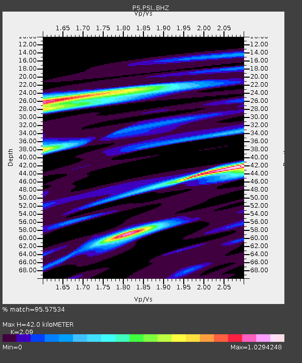
| Estimated Moho Depth: |
42.0 km |
| Estimated Crust Vp/Vs: |
2.09 |
| Assumed Crust Vp: |
6.468 km/s |
| Estimated Crust Vs: |
3.095 km/s |
| Estimated Crust Poisson's Ratio: |
0.35 |
|
| Radial Match: |
95.57534 % |
| Radial Bump: |
345 |
| Transverse Match: |
88.22483 % |
| Transverse Bump: |
400 |
| SOD ConfigId: |
3390531 |
| Insert Time: |
2019-04-14 21:07:34.318 +0000 |
| GWidth: |
2.5 |
| Max Bumps: |
400 |
| Tol: |
0.001 |
|

Signal To Noise
| Channel | StoN | STA | LTA |
| PS:PSI: :BHZ:20141107T03:42:13.610997Z | 11.409707 | 1.8313089E-6 | 1.6050446E-7 |
| PS:PSI: :BHN:20141107T03:42:13.610997Z | 1.9461188 | 3.0377353E-7 | 1.5609197E-7 |
| PS:PSI: :BHE:20141107T03:42:13.610997Z | 6.1681075 | 9.650407E-7 | 1.5645654E-7 |
| Arrivals |
| Ps | 7.4 SECOND |
| PpPs | 19 SECOND |
| PsPs/PpSs | 27 SECOND |


