You are here: Home > Network List > GH - Ghana Digital Seismic Network Stations List
> Station KUKU Kukurantumi, Ghana > Earthquake Result Viewer
KUKU Kukurantumi, Ghana - Earthquake Result Viewer
| Earthquake location: |
South Of Panama |
| Earthquake latitude/longitude: |
5.8/-78.2 |
| Earthquake time(UTC): |
2013/08/13 (225) 15:43:15 GMT |
| Earthquake Depth: |
12 km |
| Earthquake Magnitude: |
6.7 MWW, 6.6 MWB, 6.7 MWW, 6.7 MWC, 6.7 MI |
| Earthquake Catalog/Contributor: |
NEIC PDE/NEIC COMCAT |
|
| Network: |
GH Ghana Digital Seismic Network |
| Station: |
KUKU Kukurantumi, Ghana |
| Lat/Lon: |
6.19 N/0.37 W |
| Elevation: |
240 m |
|
| Distance: |
77.3 deg |
| Az: |
84.962 deg |
| Baz: |
274.519 deg |
| Ray Param: |
0.050388213 |
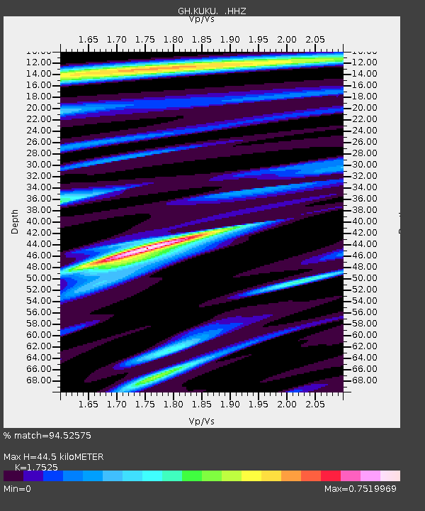
| Estimated Moho Depth: |
44.5 km |
| Estimated Crust Vp/Vs: |
1.75 |
| Assumed Crust Vp: |
6.419 km/s |
| Estimated Crust Vs: |
3.663 km/s |
| Estimated Crust Poisson's Ratio: |
0.26 |
|
| Radial Match: |
94.52575 % |
| Radial Bump: |
400 |
| Transverse Match: |
82.83317 % |
| Transverse Bump: |
400 |
| SOD ConfigId: |
626651 |
| Insert Time: |
2014-04-18 00:10:03.938 +0000 |
| GWidth: |
2.5 |
| Max Bumps: |
400 |
| Tol: |
0.001 |
|

Signal To Noise
| Channel | StoN | STA | LTA |
| GH:KUKU: :HHZ:20130813T15:54:38.249988Z | 26.050251 | 2.3043383E-6 | 8.8457426E-8 |
| GH:KUKU: :HHN:20130813T15:54:38.249988Z | 1.9753615 | 1.9836465E-7 | 1.0041941E-7 |
| GH:KUKU: :HHE:20130813T15:54:38.249988Z | 11.961968 | 9.378422E-7 | 7.8401996E-8 |
| Arrivals |
| Ps | 5.4 SECOND |
| PpPs | 18 SECOND |
| PsPs/PpSs | 24 SECOND |


