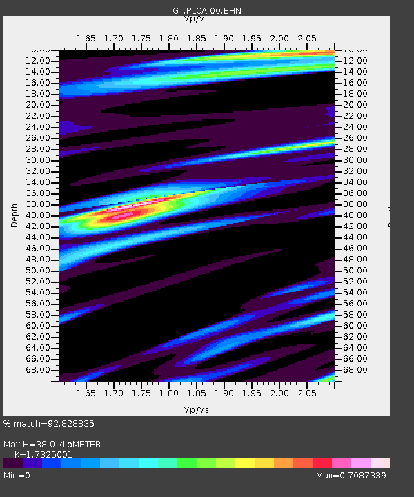
PLCA Paso Flores, Argentina - Earthquake Result Viewer
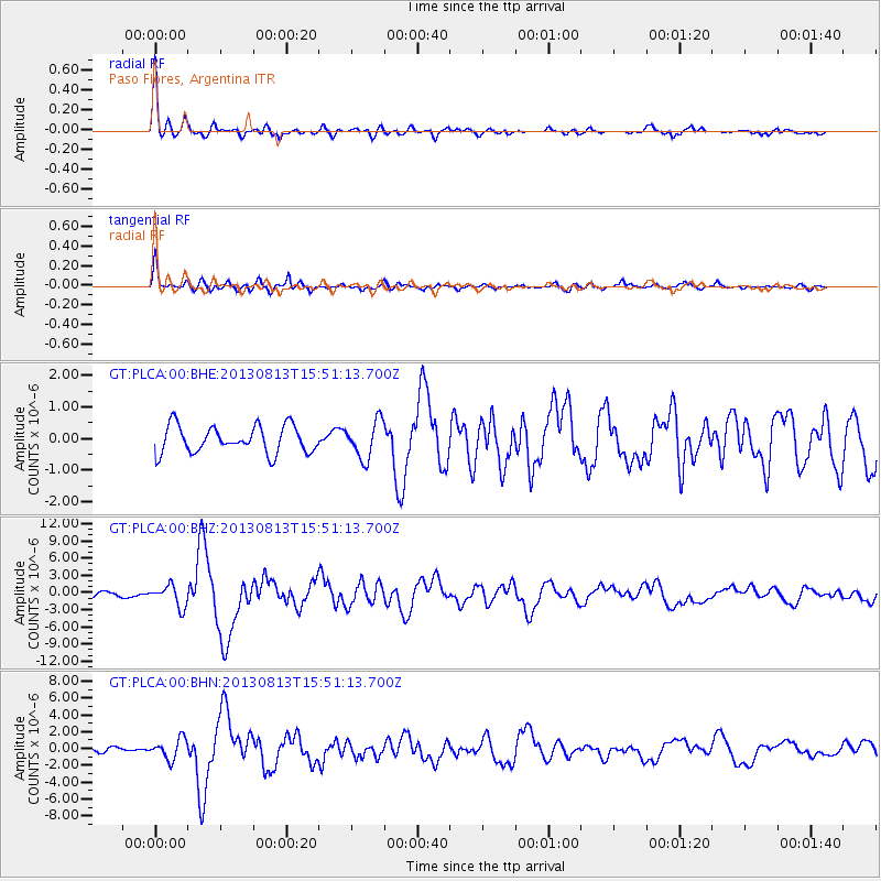
Earthquake location: South Of Panama
Earthquake latitude/longitude: 5.8/-78.2
Earthquake time(UTC): 2013/08/13 (225) 15:43:15 GMT
Earthquake Depth: 12 km
Earthquake Magnitude: 6.7 MWW, 6.6 MWB, 6.7 MWW, 6.7 MWC, 6.7 MI
Earthquake Catalog/Contributor: NEIC PDE/NEIC COMCAT
Network: GT Global Telemetered Seismograph Network (USAF/USGS)
Station: PLCA Paso Flores, Argentina
Lat/Lon: 40.73 S/70.55 W
Elevation: 1050 m
Distance: 46.8 deg
Az: 172.025 deg
Baz: 349.534 deg
Ray Param: 0.070403844
Estimated Moho Depth: 38.0 km
Estimated Crust Vp/Vs: 1.73
Assumed Crust Vp: 6.597 km/s
Estimated Crust Vs: 3.808 km/s
Estimated Crust Poisson's Ratio: 0.25
Radial Match: 92.828835 %
Radial Bump: 355
Transverse Match: 85.84995 %
Transverse Bump: 400
SOD ConfigId: 626651
Insert Time: 2014-04-18 00:10:17.044 +0000
GWidth: 2.5
Max Bumps: 400
Tol: 0.001

Signal To Noise

ChannelStoNSTALTA
GT:PLCA:00:BHZ:20130813T15:51:13.700Z3.79043361.8743194E-64.944868E-7
GT:PLCA:00:BHN:20130813T15:51:13.700Z6.4474051.199348E-61.8602027E-7
GT:PLCA:00:BHE:20130813T15:51:13.700Z1.38698675.9161994E-74.2655054E-7
Arrivals
Ps4.5 SECOND
PpPs15 SECOND
PsPs/PpSs19 SECOND