You are here: Home > Network List > NE - New England Seismic Network Stations List
> Station BRYW Smithfield, RI, USA > Earthquake Result Viewer
BRYW Smithfield, RI, USA - Earthquake Result Viewer
| Earthquake location: |
South Of Panama |
| Earthquake latitude/longitude: |
5.8/-78.2 |
| Earthquake time(UTC): |
2013/08/13 (225) 15:43:15 GMT |
| Earthquake Depth: |
12 km |
| Earthquake Magnitude: |
6.7 MWW, 6.6 MWB, 6.7 MWW, 6.7 MWC, 6.7 MI |
| Earthquake Catalog/Contributor: |
NEIC PDE/NEIC COMCAT |
|
| Network: |
NE New England Seismic Network |
| Station: |
BRYW Smithfield, RI, USA |
| Lat/Lon: |
41.92 N/71.54 W |
| Elevation: |
116 m |
|
| Distance: |
36.5 deg |
| Az: |
8.375 deg |
| Baz: |
191.196 deg |
| Ray Param: |
0.0766545 |
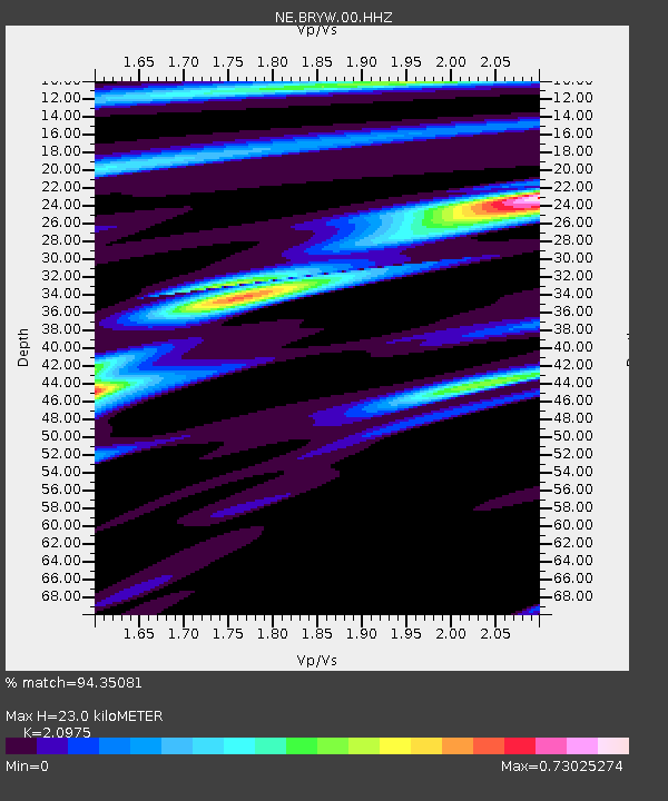
| Estimated Moho Depth: |
23.0 km |
| Estimated Crust Vp/Vs: |
2.10 |
| Assumed Crust Vp: |
6.472 km/s |
| Estimated Crust Vs: |
3.086 km/s |
| Estimated Crust Poisson's Ratio: |
0.35 |
|
| Radial Match: |
94.35081 % |
| Radial Bump: |
290 |
| Transverse Match: |
81.977554 % |
| Transverse Bump: |
400 |
| SOD ConfigId: |
626651 |
| Insert Time: |
2014-04-18 00:15:28.843 +0000 |
| GWidth: |
2.5 |
| Max Bumps: |
400 |
| Tol: |
0.001 |
|

Signal To Noise
| Channel | StoN | STA | LTA |
| NE:BRYW:00:HHZ:20130813T15:49:49.214008Z | 6.97723 | 9.993232E-7 | 1.4322636E-7 |
| NE:BRYW:00:HH1:20130813T15:49:49.214008Z | 3.3684578 | 5.9936747E-7 | 1.7793528E-7 |
| NE:BRYW:00:HH2:20130813T15:49:49.214008Z | 1.3271456 | 1.8051622E-7 | 1.360184E-7 |
| Arrivals |
| Ps | 4.2 SECOND |
| PpPs | 10 SECOND |
| PsPs/PpSs | 14 SECOND |


