You are here: Home > Network List > NM - Cooperative New Madrid Seismic Network Stations List
> Station MGMO Mountain Grove, MO > Earthquake Result Viewer
MGMO Mountain Grove, MO - Earthquake Result Viewer
| Earthquake location: |
South Of Panama |
| Earthquake latitude/longitude: |
5.8/-78.2 |
| Earthquake time(UTC): |
2013/08/13 (225) 15:43:15 GMT |
| Earthquake Depth: |
12 km |
| Earthquake Magnitude: |
6.7 MWW, 6.6 MWB, 6.7 MWW, 6.7 MWC, 6.7 MI |
| Earthquake Catalog/Contributor: |
NEIC PDE/NEIC COMCAT |
|
| Network: |
NM Cooperative New Madrid Seismic Network |
| Station: |
MGMO Mountain Grove, MO |
| Lat/Lon: |
37.15 N/92.27 W |
| Elevation: |
453 m |
|
| Distance: |
33.8 deg |
| Az: |
339.553 deg |
| Baz: |
154.211 deg |
| Ray Param: |
0.078047365 |
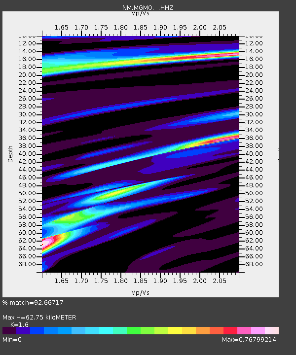
| Estimated Moho Depth: |
62.75 km |
| Estimated Crust Vp/Vs: |
1.60 |
| Assumed Crust Vp: |
6.53 km/s |
| Estimated Crust Vs: |
4.082 km/s |
| Estimated Crust Poisson's Ratio: |
0.18 |
|
| Radial Match: |
92.66717 % |
| Radial Bump: |
238 |
| Transverse Match: |
80.448906 % |
| Transverse Bump: |
389 |
| SOD ConfigId: |
626651 |
| Insert Time: |
2014-04-18 00:16:51.282 +0000 |
| GWidth: |
2.5 |
| Max Bumps: |
400 |
| Tol: |
0.001 |
|

Signal To Noise
| Channel | StoN | STA | LTA |
| NM:MGMO: :HHZ:20130813T15:49:26.017993Z | 18.427 | 3.0508004E-6 | 1.6556143E-7 |
| NM:MGMO: :HHN:20130813T15:49:26.017993Z | 9.171665 | 1.8548056E-6 | 2.0223214E-7 |
| NM:MGMO: :HHE:20130813T15:49:26.017993Z | 6.260631 | 6.1084006E-7 | 9.756845E-8 |
| Arrivals |
| Ps | 6.3 SECOND |
| PpPs | 23 SECOND |
| PsPs/PpSs | 29 SECOND |


