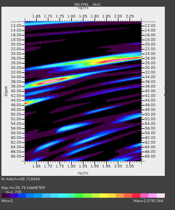
PRN Pahroc Range, Nevada. (GPS 12/04/2000) w84 - Earthquake Result Viewer

Earthquake location: South Of Panama
Earthquake latitude/longitude: 5.8/-78.2
Earthquake time(UTC): 2013/08/13 (225) 15:43:15 GMT
Earthquake Depth: 12 km
Earthquake Magnitude: 6.7 MWW, 6.6 MWB, 6.7 MWW, 6.7 MWC, 6.7 MI
Earthquake Catalog/Contributor: NEIC PDE/NEIC COMCAT
Network: NN Western Great Basin/Eastern Sierra Nevada
Station: PRN Pahroc Range, Nevada. (GPS 12/04/2000) w84
Lat/Lon: 37.41 N/115.05 W
Elevation: 1464 m
Distance: 46.0 deg
Az: 318.415 deg
Baz: 123.969 deg
Ray Param: 0.07090063
Estimated Moho Depth: 35.75 km
Estimated Crust Vp/Vs: 1.71
Assumed Crust Vp: 6.276 km/s
Estimated Crust Vs: 3.681 km/s
Estimated Crust Poisson's Ratio: 0.24
Radial Match: 88.716484 %
Radial Bump: 400
Transverse Match: 74.76529 %
Transverse Bump: 400
SOD ConfigId: 626651
Insert Time: 2014-04-18 00:17:34.037 +0000
GWidth: 2.5
Max Bumps: 400
Tol: 0.001

Signal To Noise

ChannelStoNSTALTA
NN:PRN: :HHZ:20130813T15:51:07.474994Z31.60411.4258815E-64.511698E-8
NN:PRN: :HHN:20130813T15:51:07.474994Z8.6751554.0210315E-74.6351122E-8
NN:PRN: :HHE:20130813T15:51:07.474994Z6.1566495.125067E-78.3244416E-8
Arrivals
Ps4.3 SECOND
PpPs14 SECOND
PsPs/PpSs19 SECOND