You are here: Home > Network List > OK - Oklahoma Seismic Network Stations List
> Station FNO Franklin, Norman, OK > Earthquake Result Viewer
FNO Franklin, Norman, OK - Earthquake Result Viewer
| Earthquake location: |
South Of Panama |
| Earthquake latitude/longitude: |
5.8/-78.2 |
| Earthquake time(UTC): |
2013/08/13 (225) 15:43:15 GMT |
| Earthquake Depth: |
12 km |
| Earthquake Magnitude: |
6.7 MWW, 6.6 MWB, 6.7 MWW, 6.7 MWC, 6.7 MI |
| Earthquake Catalog/Contributor: |
NEIC PDE/NEIC COMCAT |
|
| Network: |
OK Oklahoma Seismic Network |
| Station: |
FNO Franklin, Norman, OK |
| Lat/Lon: |
35.26 N/97.40 W |
| Elevation: |
360 m |
|
| Distance: |
34.3 deg |
| Az: |
331.443 deg |
| Baz: |
144.466 deg |
| Ray Param: |
0.07782131 |
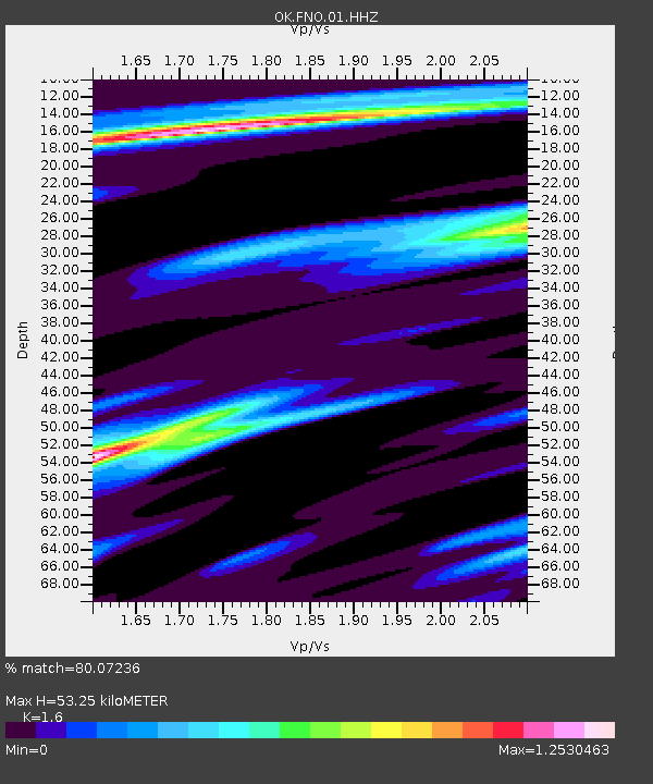
| Estimated Moho Depth: |
53.25 km |
| Estimated Crust Vp/Vs: |
1.60 |
| Assumed Crust Vp: |
6.426 km/s |
| Estimated Crust Vs: |
4.016 km/s |
| Estimated Crust Poisson's Ratio: |
0.18 |
|
| Radial Match: |
80.07236 % |
| Radial Bump: |
260 |
| Transverse Match: |
62.221397 % |
| Transverse Bump: |
400 |
| SOD ConfigId: |
626651 |
| Insert Time: |
2014-04-18 00:18:22.983 +0000 |
| GWidth: |
2.5 |
| Max Bumps: |
400 |
| Tol: |
0.001 |
|

Signal To Noise
| Channel | StoN | STA | LTA |
| OK:FNO:01:HHZ:20130813T15:49:30.270007Z | 36.52877 | 6.5251966E-6 | 1.7863171E-7 |
| OK:FNO:01:HHN:20130813T15:49:30.270007Z | 3.4857159 | 1.5275454E-6 | 4.3823002E-7 |
| OK:FNO:01:HHE:20130813T15:49:30.270007Z | 3.6647692 | 1.5660927E-6 | 4.273373E-7 |
| Arrivals |
| Ps | 5.4 SECOND |
| PpPs | 20 SECOND |
| PsPs/PpSs | 25 SECOND |


