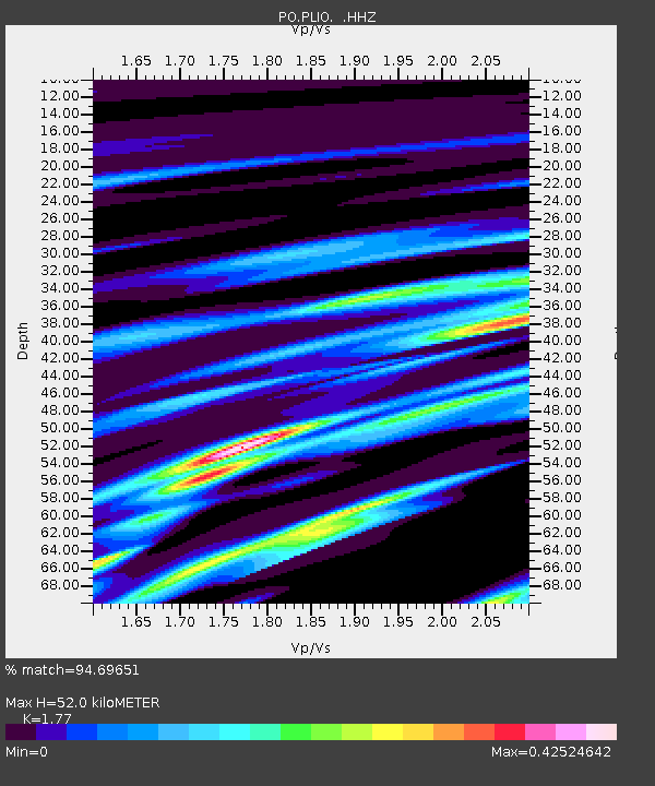
PLIO PELEE ISLAND, ON - Earthquake Result Viewer

Earthquake location: South Of Panama
Earthquake latitude/longitude: 5.8/-78.2
Earthquake time(UTC): 2013/08/13 (225) 15:43:15 GMT
Earthquake Depth: 12 km
Earthquake Magnitude: 6.7 MWW, 6.6 MWB, 6.7 MWW, 6.7 MWC, 6.7 MI
Earthquake Catalog/Contributor: NEIC PDE/NEIC COMCAT
Network: PO Portable Observatories for Lithospheric Analysis and Research Investigating Seis
Station: PLIO PELEE ISLAND, ON
Lat/Lon: 41.75 N/82.63 W
Elevation: 143 m
Distance: 36.0 deg
Az: 354.365 deg
Baz: 172.497 deg
Ray Param: 0.076891676
Estimated Moho Depth: 52.0 km
Estimated Crust Vp/Vs: 1.77
Assumed Crust Vp: 6.498 km/s
Estimated Crust Vs: 3.671 km/s
Estimated Crust Poisson's Ratio: 0.27
Radial Match: 94.69651 %
Radial Bump: 183
Transverse Match: 79.34169 %
Transverse Bump: 400
SOD ConfigId: 626651
Insert Time: 2014-04-18 00:20:17.474 +0000
GWidth: 2.5
Max Bumps: 400
Tol: 0.001

Signal To Noise

ChannelStoNSTALTA
PO:PLIO: :HHZ:20130813T15:49:45.509998Z9.7223081.1566103E-61.18964586E-7
PO:PLIO: :HHN:20130813T15:49:45.509998Z6.72705847.200989E-71.07045146E-7
PO:PLIO: :HHE:20130813T15:49:45.509998Z2.30995771.3421807E-75.8104128E-8
Arrivals
Ps6.7 SECOND
PpPs21 SECOND
PsPs/PpSs27 SECOND