You are here: Home > Network List > TA - USArray Transportable Network (new EarthScope stations) Stations List
> Station E54A Lac Daplat, Pontiac, MRC, QC, CAN > Earthquake Result Viewer
E54A Lac Daplat, Pontiac, MRC, QC, CAN - Earthquake Result Viewer
| Earthquake location: |
South Of Panama |
| Earthquake latitude/longitude: |
5.8/-78.2 |
| Earthquake time(UTC): |
2013/08/13 (225) 15:43:15 GMT |
| Earthquake Depth: |
12 km |
| Earthquake Magnitude: |
6.7 MWW, 6.6 MWB, 6.7 MWW, 6.7 MWC, 6.7 MI |
| Earthquake Catalog/Contributor: |
NEIC PDE/NEIC COMCAT |
|
| Network: |
TA USArray Transportable Network (new EarthScope stations) |
| Station: |
E54A Lac Daplat, Pontiac, MRC, QC, CAN |
| Lat/Lon: |
46.43 N/77.19 W |
| Elevation: |
277 m |
|
| Distance: |
40.5 deg |
| Az: |
1.078 deg |
| Baz: |
181.552 deg |
| Ray Param: |
0.0743512 |
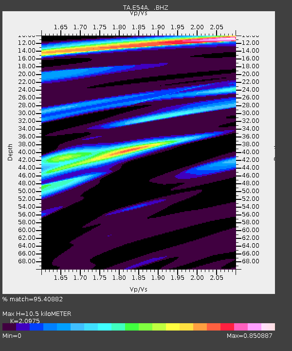
| Estimated Moho Depth: |
10.5 km |
| Estimated Crust Vp/Vs: |
2.10 |
| Assumed Crust Vp: |
6.622 km/s |
| Estimated Crust Vs: |
3.157 km/s |
| Estimated Crust Poisson's Ratio: |
0.35 |
|
| Radial Match: |
95.40882 % |
| Radial Bump: |
256 |
| Transverse Match: |
67.39148 % |
| Transverse Bump: |
400 |
| SOD ConfigId: |
626651 |
| Insert Time: |
2014-04-18 00:23:32.572 +0000 |
| GWidth: |
2.5 |
| Max Bumps: |
400 |
| Tol: |
0.001 |
|
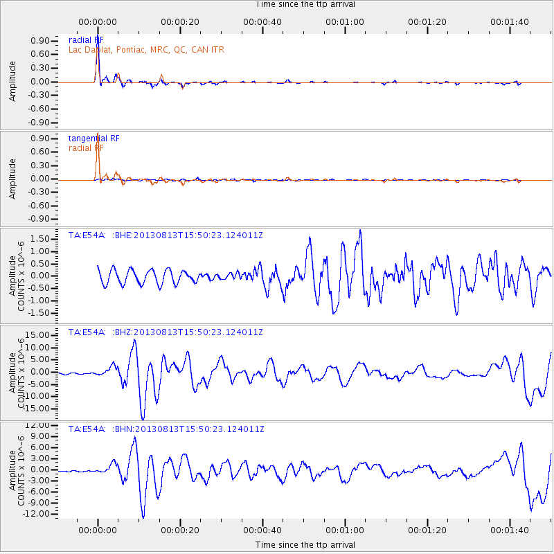
Signal To Noise
| Channel | StoN | STA | LTA |
| TA:E54A: :BHZ:20130813T15:50:23.124011Z | 5.7061315 | 2.0852035E-6 | 3.6543207E-7 |
| TA:E54A: :BHN:20130813T15:50:23.124011Z | 6.916066 | 1.3785318E-6 | 1.9932311E-7 |
| TA:E54A: :BHE:20130813T15:50:23.124011Z | 0.44585443 | 1.2031029E-7 | 2.6984208E-7 |
| Arrivals |
| Ps | 1.9 SECOND |
| PpPs | 4.6 SECOND |
| PsPs/PpSs | 6.5 SECOND |


