You are here: Home > Network List > TA - USArray Transportable Network (new EarthScope stations) Stations List
> Station E55A Montcerf-Lytton, QC, CAN > Earthquake Result Viewer
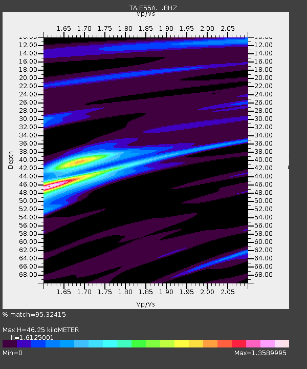
E55A Montcerf-Lytton, QC, CAN - Earthquake Result Viewer
| Earthquake location: |
South Of Panama |
| Earthquake latitude/longitude: |
5.8/-78.2 |
| Earthquake time(UTC): |
2013/08/13 (225) 15:43:15 GMT |
| Earthquake Depth: |
12 km |
| Earthquake Magnitude: |
6.7 MWW, 6.6 MWB, 6.7 MWW, 6.7 MWC, 6.7 MI |
| Earthquake Catalog/Contributor: |
NEIC PDE/NEIC COMCAT |
|
| Network: |
TA USArray Transportable Network (new EarthScope stations) |
| Station: |
E55A Montcerf-Lytton, QC, CAN |
| Lat/Lon: |
46.45 N/76.06 W |
| Elevation: |
180 m |
|
| Distance: |
40.6 deg |
| Az: |
2.278 deg |
| Baz: |
183.279 deg |
| Ray Param: |
0.07432 |
| Estimated Moho Depth: |
46.25 km |
| Estimated Crust Vp/Vs: |
1.61 |
| Assumed Crust Vp: |
6.622 km/s |
| Estimated Crust Vs: |
4.107 km/s |
| Estimated Crust Poisson's Ratio: |
0.19 |
|
| Radial Match: |
95.32415 % |
| Radial Bump: |
205 |
| Transverse Match: |
72.24108 % |
| Transverse Bump: |
400 |
| SOD ConfigId: |
626651 |
| Insert Time: |
2014-04-18 00:23:36.174 +0000 |
| GWidth: |
2.5 |
| Max Bumps: |
400 |
| Tol: |
0.001 |
|

Signal To Noise
| Channel | StoN | STA | LTA |
| TA:E55A: :BHZ:20130813T15:50:23.550006Z | 6.776717 | 1.8210231E-6 | 2.687176E-7 |
| TA:E55A: :BHN:20130813T15:50:23.550006Z | 4.987429 | 1.2818695E-6 | 2.5702008E-7 |
| TA:E55A: :BHE:20130813T15:50:23.550006Z | 1.5466651 | 4.0242134E-7 | 2.6018648E-7 |
| Arrivals |
| Ps | 4.6 SECOND |
| PpPs | 17 SECOND |
| PsPs/PpSs | 21 SECOND |


