You are here: Home > Network List > TA - USArray Transportable Network (new EarthScope stations) Stations List
> Station G57A Newington, ON, CAN > Earthquake Result Viewer
G57A Newington, ON, CAN - Earthquake Result Viewer
| Earthquake location: |
South Of Panama |
| Earthquake latitude/longitude: |
5.8/-78.2 |
| Earthquake time(UTC): |
2013/08/13 (225) 15:43:15 GMT |
| Earthquake Depth: |
12 km |
| Earthquake Magnitude: |
6.7 MWW, 6.6 MWB, 6.7 MWW, 6.7 MWC, 6.7 MI |
| Earthquake Catalog/Contributor: |
NEIC PDE/NEIC COMCAT |
|
| Network: |
TA USArray Transportable Network (new EarthScope stations) |
| Station: |
G57A Newington, ON, CAN |
| Lat/Lon: |
45.10 N/74.99 W |
| Elevation: |
96 m |
|
| Distance: |
39.3 deg |
| Az: |
3.596 deg |
| Baz: |
185.056 deg |
| Ray Param: |
0.07507232 |
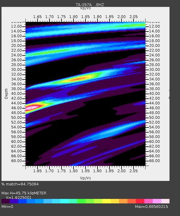
| Estimated Moho Depth: |
45.75 km |
| Estimated Crust Vp/Vs: |
1.62 |
| Assumed Crust Vp: |
6.419 km/s |
| Estimated Crust Vs: |
3.956 km/s |
| Estimated Crust Poisson's Ratio: |
0.19 |
|
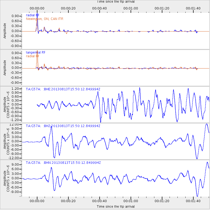
| Radial Match: |
94.75094 % |
| Radial Bump: |
194 |
| Transverse Match: |
77.531456 % |
| Transverse Bump: |
400 |
| SOD ConfigId: |
626651 |
| Insert Time: |
2014-04-18 00:25:02.509 +0000 |
| GWidth: |
2.5 |
| Max Bumps: |
400 |
| Tol: |
0.001 |
|
Signal To Noise
| Channel | StoN | STA | LTA |
| TA:G57A: :BHZ:20130813T15:50:12.849994Z | 6.091636 | 1.6661853E-6 | 2.7352016E-7 |
| TA:G57A: :BHN:20130813T15:50:12.849994Z | 4.337167 | 9.2836854E-7 | 2.1404955E-7 |
| TA:G57A: :BHE:20130813T15:50:12.849994Z | 0.97386163 | 1.4301088E-7 | 1.4684927E-7 |
| Arrivals |
| Ps | 4.8 SECOND |
| PpPs | 17 SECOND |
| PsPs/PpSs | 22 SECOND |


