You are here: Home > Network List > TA - USArray Transportable Network (new EarthScope stations) Stations List
> Station H46A Fife Lake, MI, USA > Earthquake Result Viewer
H46A Fife Lake, MI, USA - Earthquake Result Viewer
| Earthquake location: |
South Of Panama |
| Earthquake latitude/longitude: |
5.8/-78.2 |
| Earthquake time(UTC): |
2013/08/13 (225) 15:43:15 GMT |
| Earthquake Depth: |
12 km |
| Earthquake Magnitude: |
6.7 MWW, 6.6 MWB, 6.7 MWW, 6.7 MWC, 6.7 MI |
| Earthquake Catalog/Contributor: |
NEIC PDE/NEIC COMCAT |
|
| Network: |
TA USArray Transportable Network (new EarthScope stations) |
| Station: |
H46A Fife Lake, MI, USA |
| Lat/Lon: |
44.54 N/85.20 W |
| Elevation: |
329 m |
|
| Distance: |
39.1 deg |
| Az: |
352.053 deg |
| Baz: |
168.909 deg |
| Ray Param: |
0.075175956 |
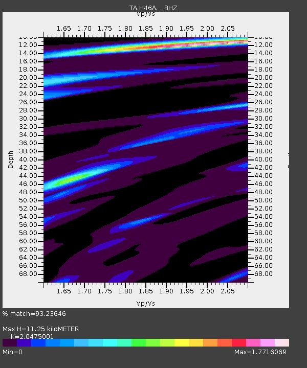
| Estimated Moho Depth: |
11.25 km |
| Estimated Crust Vp/Vs: |
2.05 |
| Assumed Crust Vp: |
6.483 km/s |
| Estimated Crust Vs: |
3.166 km/s |
| Estimated Crust Poisson's Ratio: |
0.34 |
|
| Radial Match: |
93.23646 % |
| Radial Bump: |
368 |
| Transverse Match: |
75.39869 % |
| Transverse Bump: |
400 |
| SOD ConfigId: |
626651 |
| Insert Time: |
2014-04-18 00:25:20.243 +0000 |
| GWidth: |
2.5 |
| Max Bumps: |
400 |
| Tol: |
0.001 |
|

Signal To Noise
| Channel | StoN | STA | LTA |
| TA:H46A: :BHZ:20130813T15:50:11.349994Z | 14.667159 | 3.6377205E-6 | 2.4801807E-7 |
| TA:H46A: :BHN:20130813T15:50:11.349994Z | 6.4005036 | 2.2395095E-6 | 3.4989583E-7 |
| TA:H46A: :BHE:20130813T15:50:11.349994Z | 1.863532 | 6.913501E-7 | 3.7098914E-7 |
| Arrivals |
| Ps | 1.9 SECOND |
| PpPs | 5.0 SECOND |
| PsPs/PpSs | 6.9 SECOND |


