You are here: Home > Network List > TA - USArray Transportable Network (new EarthScope stations) Stations List
> Station H47A Mio, MI, USA > Earthquake Result Viewer
H47A Mio, MI, USA - Earthquake Result Viewer
| Earthquake location: |
South Of Panama |
| Earthquake latitude/longitude: |
5.8/-78.2 |
| Earthquake time(UTC): |
2013/08/13 (225) 15:43:15 GMT |
| Earthquake Depth: |
12 km |
| Earthquake Magnitude: |
6.7 MWW, 6.6 MWB, 6.7 MWW, 6.7 MWC, 6.7 MI |
| Earthquake Catalog/Contributor: |
NEIC PDE/NEIC COMCAT |
|
| Network: |
TA USArray Transportable Network (new EarthScope stations) |
| Station: |
H47A Mio, MI, USA |
| Lat/Lon: |
44.60 N/84.21 W |
| Elevation: |
356 m |
|
| Distance: |
39.0 deg |
| Az: |
353.182 deg |
| Baz: |
170.483 deg |
| Ray Param: |
0.075215675 |
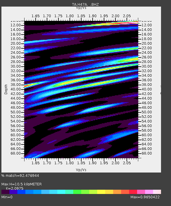
| Estimated Moho Depth: |
10.5 km |
| Estimated Crust Vp/Vs: |
2.10 |
| Assumed Crust Vp: |
6.483 km/s |
| Estimated Crust Vs: |
3.091 km/s |
| Estimated Crust Poisson's Ratio: |
0.35 |
|
| Radial Match: |
92.476944 % |
| Radial Bump: |
400 |
| Transverse Match: |
56.021698 % |
| Transverse Bump: |
400 |
| SOD ConfigId: |
626651 |
| Insert Time: |
2014-04-18 00:25:23.569 +0000 |
| GWidth: |
2.5 |
| Max Bumps: |
400 |
| Tol: |
0.001 |
|
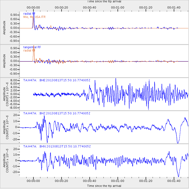
Signal To Noise
| Channel | StoN | STA | LTA |
| TA:H47A: :BHZ:20130813T15:50:10.774005Z | 20.07465 | 3.964059E-6 | 1.9746591E-7 |
| TA:H47A: :BHN:20130813T15:50:10.774005Z | 6.308492 | 2.352479E-6 | 3.729067E-7 |
| TA:H47A: :BHE:20130813T15:50:10.774005Z | 1.1689508 | 5.892449E-7 | 5.040802E-7 |
| Arrivals |
| Ps | 1.9 SECOND |
| PpPs | 4.7 SECOND |
| PsPs/PpSs | 6.6 SECOND |


