You are here: Home > Network List > TA - USArray Transportable Network (new EarthScope stations) Stations List
> Station I45A Fountain, MI, USA > Earthquake Result Viewer
I45A Fountain, MI, USA - Earthquake Result Viewer
| Earthquake location: |
South Of Panama |
| Earthquake latitude/longitude: |
5.8/-78.2 |
| Earthquake time(UTC): |
2013/08/13 (225) 15:43:15 GMT |
| Earthquake Depth: |
12 km |
| Earthquake Magnitude: |
6.7 MWW, 6.6 MWB, 6.7 MWW, 6.7 MWC, 6.7 MI |
| Earthquake Catalog/Contributor: |
NEIC PDE/NEIC COMCAT |
|
| Network: |
TA USArray Transportable Network (new EarthScope stations) |
| Station: |
I45A Fountain, MI, USA |
| Lat/Lon: |
44.04 N/86.23 W |
| Elevation: |
215 m |
|
| Distance: |
38.8 deg |
| Az: |
350.733 deg |
| Baz: |
167.164 deg |
| Ray Param: |
0.075371765 |
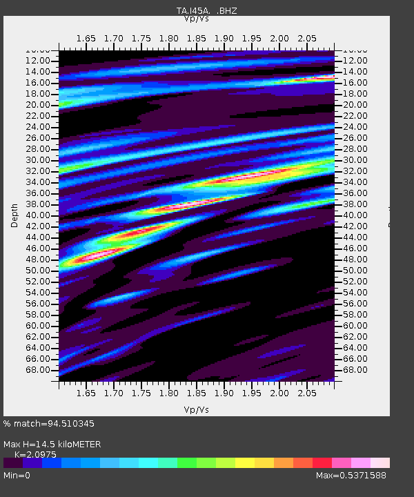
| Estimated Moho Depth: |
14.5 km |
| Estimated Crust Vp/Vs: |
2.10 |
| Assumed Crust Vp: |
6.53 km/s |
| Estimated Crust Vs: |
3.113 km/s |
| Estimated Crust Poisson's Ratio: |
0.35 |
|
| Radial Match: |
94.510345 % |
| Radial Bump: |
374 |
| Transverse Match: |
64.83525 % |
| Transverse Bump: |
400 |
| SOD ConfigId: |
626651 |
| Insert Time: |
2014-04-18 00:25:55.415 +0000 |
| GWidth: |
2.5 |
| Max Bumps: |
400 |
| Tol: |
0.001 |
|
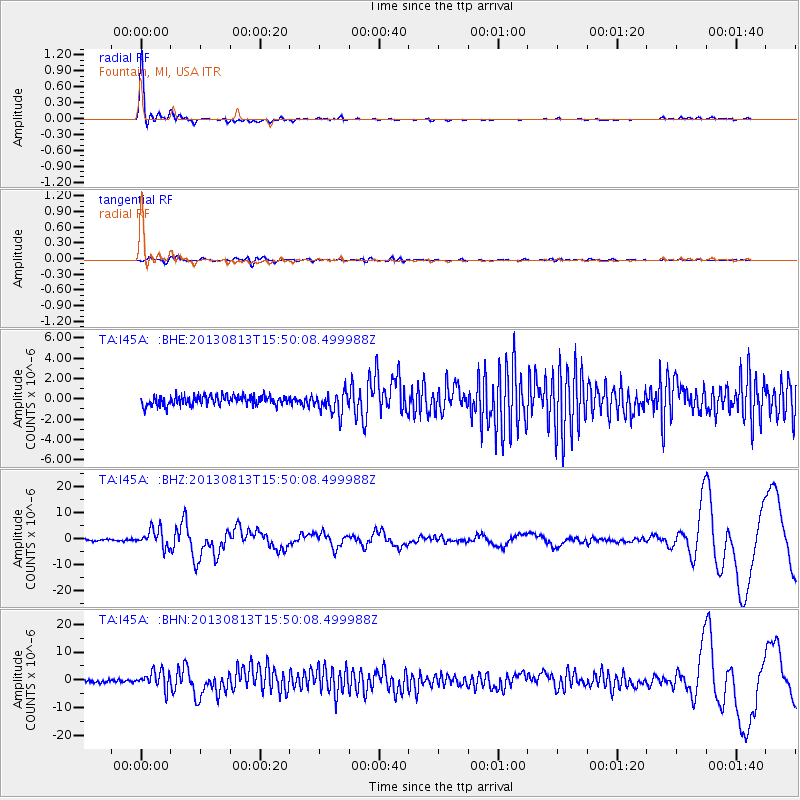
Signal To Noise
| Channel | StoN | STA | LTA |
| TA:I45A: :BHZ:20130813T15:50:08.499988Z | 10.068702 | 3.5600333E-6 | 3.5357422E-7 |
| TA:I45A: :BHN:20130813T15:50:08.499988Z | 4.2906146 | 3.0989395E-6 | 7.222601E-7 |
| TA:I45A: :BHE:20130813T15:50:08.499988Z | 2.2941883 | 1.0651355E-6 | 4.642755E-7 |
| Arrivals |
| Ps | 2.6 SECOND |
| PpPs | 6.5 SECOND |
| PsPs/PpSs | 9.1 SECOND |


