You are here: Home > Network List > TA - USArray Transportable Network (new EarthScope stations) Stations List
> Station I55A Frankford, ON, CAN > Earthquake Result Viewer
I55A Frankford, ON, CAN - Earthquake Result Viewer
| Earthquake location: |
South Of Panama |
| Earthquake latitude/longitude: |
5.8/-78.2 |
| Earthquake time(UTC): |
2013/08/13 (225) 15:43:15 GMT |
| Earthquake Depth: |
12 km |
| Earthquake Magnitude: |
6.7 MWW, 6.6 MWB, 6.7 MWW, 6.7 MWC, 6.7 MI |
| Earthquake Catalog/Contributor: |
NEIC PDE/NEIC COMCAT |
|
| Network: |
TA USArray Transportable Network (new EarthScope stations) |
| Station: |
I55A Frankford, ON, CAN |
| Lat/Lon: |
44.22 N/77.68 W |
| Elevation: |
132 m |
|
| Distance: |
38.3 deg |
| Az: |
0.601 deg |
| Baz: |
180.832 deg |
| Ray Param: |
0.075641304 |
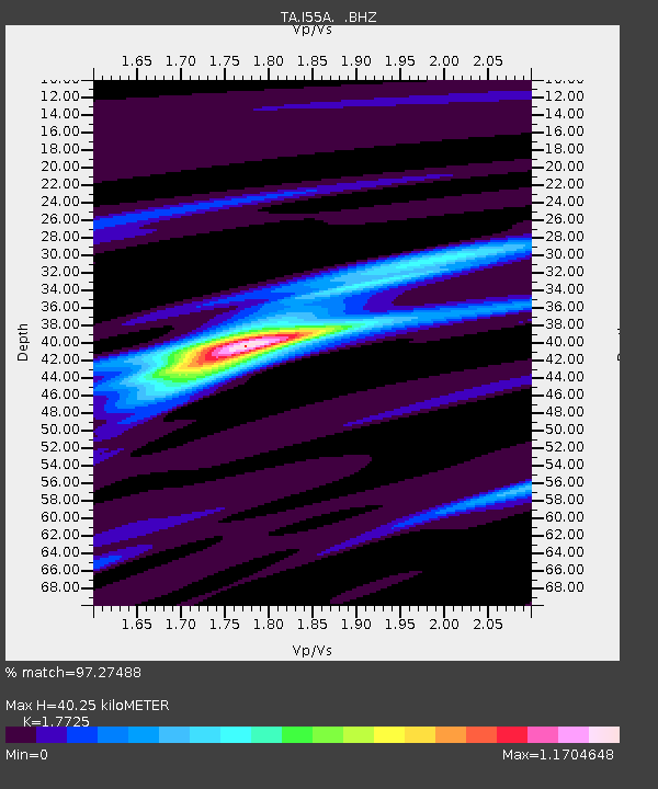
| Estimated Moho Depth: |
40.25 km |
| Estimated Crust Vp/Vs: |
1.77 |
| Assumed Crust Vp: |
6.577 km/s |
| Estimated Crust Vs: |
3.711 km/s |
| Estimated Crust Poisson's Ratio: |
0.27 |
|
| Radial Match: |
97.27488 % |
| Radial Bump: |
145 |
| Transverse Match: |
75.98528 % |
| Transverse Bump: |
393 |
| SOD ConfigId: |
626651 |
| Insert Time: |
2014-04-18 00:26:16.290 +0000 |
| GWidth: |
2.5 |
| Max Bumps: |
400 |
| Tol: |
0.001 |
|
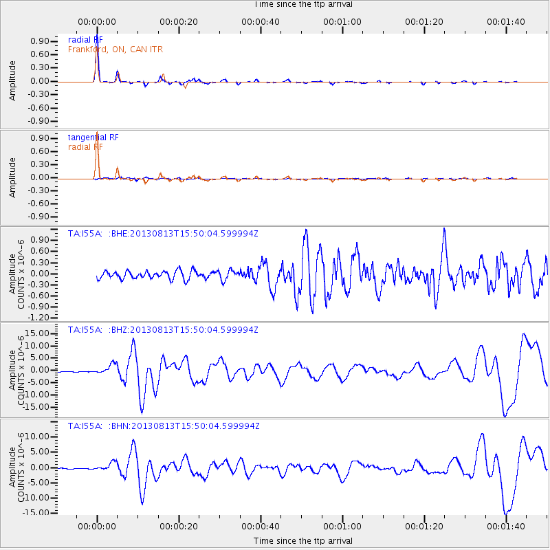
Signal To Noise
| Channel | StoN | STA | LTA |
| TA:I55A: :BHZ:20130813T15:50:04.599994Z | 15.35206 | 2.1545463E-6 | 1.403425E-7 |
| TA:I55A: :BHN:20130813T15:50:04.599994Z | 8.0969925 | 1.4417334E-6 | 1.780579E-7 |
| TA:I55A: :BHE:20130813T15:50:04.599994Z | 1.2466651 | 1.3480205E-7 | 1.08130116E-7 |
| Arrivals |
| Ps | 5.1 SECOND |
| PpPs | 16 SECOND |
| PsPs/PpSs | 21 SECOND |


