You are here: Home > Network List > TA - USArray Transportable Network (new EarthScope stations) Stations List
> Station J04D Umpqua National Forest, Toketee, OR, USA > Earthquake Result Viewer
J04D Umpqua National Forest, Toketee, OR, USA - Earthquake Result Viewer
| Earthquake location: |
South Of Panama |
| Earthquake latitude/longitude: |
5.8/-78.2 |
| Earthquake time(UTC): |
2013/08/13 (225) 15:43:15 GMT |
| Earthquake Depth: |
12 km |
| Earthquake Magnitude: |
6.7 MWW, 6.6 MWB, 6.7 MWW, 6.7 MWC, 6.7 MI |
| Earthquake Catalog/Contributor: |
NEIC PDE/NEIC COMCAT |
|
| Network: |
TA USArray Transportable Network (new EarthScope stations) |
| Station: |
J04D Umpqua National Forest, Toketee, OR, USA |
| Lat/Lon: |
43.24 N/122.11 W |
| Elevation: |
1948 m |
|
| Distance: |
53.7 deg |
| Az: |
321.033 deg |
| Baz: |
121.102 deg |
| Ray Param: |
0.06592125 |
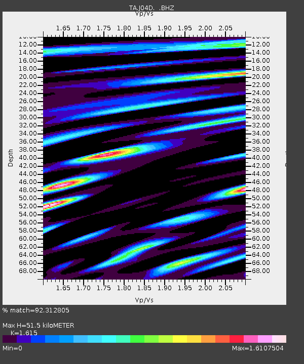
| Estimated Moho Depth: |
51.5 km |
| Estimated Crust Vp/Vs: |
1.62 |
| Assumed Crust Vp: |
6.522 km/s |
| Estimated Crust Vs: |
4.038 km/s |
| Estimated Crust Poisson's Ratio: |
0.19 |
|
| Radial Match: |
92.312805 % |
| Radial Bump: |
400 |
| Transverse Match: |
92.14586 % |
| Transverse Bump: |
400 |
| SOD ConfigId: |
626651 |
| Insert Time: |
2014-04-18 00:26:25.992 +0000 |
| GWidth: |
2.5 |
| Max Bumps: |
400 |
| Tol: |
0.001 |
|
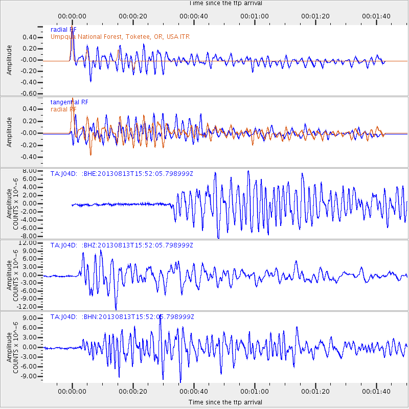
Signal To Noise
| Channel | StoN | STA | LTA |
| TA:J04D: :BHZ:20130813T15:52:05.798999Z | 23.3881 | 2.8539203E-6 | 1.2202446E-7 |
| TA:J04D: :BHN:20130813T15:52:05.798999Z | 6.8479896 | 8.2856354E-7 | 1.209937E-7 |
| TA:J04D: :BHE:20130813T15:52:05.798999Z | 9.976798 | 1.3954141E-6 | 1.3986593E-7 |
| Arrivals |
| Ps | 5.2 SECOND |
| PpPs | 19 SECOND |
| PsPs/PpSs | 25 SECOND |


