You are here: Home > Network List > TA - USArray Transportable Network (new EarthScope stations) Stations List
> Station J05D Fort Rock, OR, USA > Earthquake Result Viewer
J05D Fort Rock, OR, USA - Earthquake Result Viewer
| Earthquake location: |
South Of Panama |
| Earthquake latitude/longitude: |
5.8/-78.2 |
| Earthquake time(UTC): |
2013/08/13 (225) 15:43:15 GMT |
| Earthquake Depth: |
12 km |
| Earthquake Magnitude: |
6.7 MWW, 6.6 MWB, 6.7 MWW, 6.7 MWC, 6.7 MI |
| Earthquake Catalog/Contributor: |
NEIC PDE/NEIC COMCAT |
|
| Network: |
TA USArray Transportable Network (new EarthScope stations) |
| Station: |
J05D Fort Rock, OR, USA |
| Lat/Lon: |
43.28 N/121.23 W |
| Elevation: |
1541 m |
|
| Distance: |
53.2 deg |
| Az: |
321.496 deg |
| Baz: |
121.975 deg |
| Ray Param: |
0.06627081 |
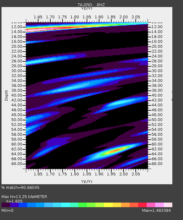
| Estimated Moho Depth: |
13.25 km |
| Estimated Crust Vp/Vs: |
1.61 |
| Assumed Crust Vp: |
6.597 km/s |
| Estimated Crust Vs: |
4.111 km/s |
| Estimated Crust Poisson's Ratio: |
0.18 |
|
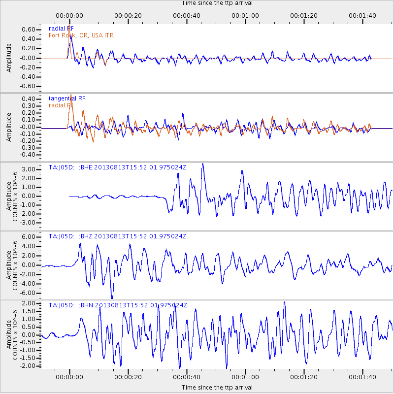
| Radial Match: |
90.66045 % |
| Radial Bump: |
400 |
| Transverse Match: |
82.40194 % |
| Transverse Bump: |
400 |
| SOD ConfigId: |
626651 |
| Insert Time: |
2014-04-18 00:26:27.541 +0000 |
| GWidth: |
2.5 |
| Max Bumps: |
400 |
| Tol: |
0.001 |
|
Signal To Noise
| Channel | StoN | STA | LTA |
| TA:J05D: :BHZ:20130813T15:52:01.975024Z | 14.111846 | 1.8142626E-6 | 1.285631E-7 |
| TA:J05D: :BHN:20130813T15:52:01.975024Z | 4.387775 | 4.9420106E-7 | 1.1263136E-7 |
| TA:J05D: :BHE:20130813T15:52:01.975024Z | 8.228775 | 7.802577E-7 | 9.482064E-8 |
| Arrivals |
| Ps | 1.3 SECOND |
| PpPs | 4.9 SECOND |
| PsPs/PpSs | 6.2 SECOND |


