You are here: Home > Network List > TA - USArray Transportable Network (new EarthScope stations) Stations List
> Station K49A Clarkson, MI, USA > Earthquake Result Viewer
K49A Clarkson, MI, USA - Earthquake Result Viewer

| Earthquake location: |
South Of Panama |
| Earthquake latitude/longitude: |
5.8/-78.2 |
| Earthquake time(UTC): |
2013/08/13 (225) 15:43:15 GMT |
| Earthquake Depth: |
12 km |
| Earthquake Magnitude: |
6.7 MWW, 6.6 MWB, 6.7 MWW, 6.7 MWC, 6.7 MI |
| Earthquake Catalog/Contributor: |
NEIC PDE/NEIC COMCAT |
|
| Network: |
TA USArray Transportable Network (new EarthScope stations) |
| Station: |
K49A Clarkson, MI, USA |
| Lat/Lon: |
42.78 N/83.46 W |
| Elevation: |
336 m |
|
| Distance: |
37.2 deg |
| Az: |
353.589 deg |
| Baz: |
171.32 deg |
| Ray Param: |
0.07628788 |
| Estimated Moho Depth: |
40.25 km |
| Estimated Crust Vp/Vs: |
1.78 |
| Assumed Crust Vp: |
6.483 km/s |
| Estimated Crust Vs: |
3.647 km/s |
| Estimated Crust Poisson's Ratio: |
0.27 |
|
| Radial Match: |
92.080124 % |
| Radial Bump: |
336 |
| Transverse Match: |
62.39283 % |
| Transverse Bump: |
400 |
| SOD ConfigId: |
626651 |
| Insert Time: |
2014-04-18 00:27:15.523 +0000 |
| GWidth: |
2.5 |
| Max Bumps: |
400 |
| Tol: |
0.001 |
|
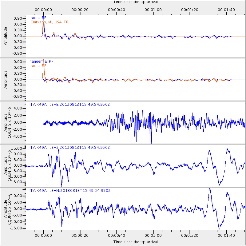
Signal To Noise
| Channel | StoN | STA | LTA |
| TA:K49A: :BHZ:20130813T15:49:54.950Z | 18.530878 | 3.995844E-6 | 2.1563167E-7 |
| TA:K49A: :BHN:20130813T15:49:54.950Z | 7.7789297 | 2.0866964E-6 | 2.682498E-7 |
| TA:K49A: :BHE:20130813T15:49:54.950Z | 1.651727 | 4.9318487E-7 | 2.9858742E-7 |
| Arrivals |
| Ps | 5.2 SECOND |
| PpPs | 16 SECOND |
| PsPs/PpSs | 21 SECOND |


