You are here: Home > Network List > TA - USArray Transportable Network (new EarthScope stations) Stations List
> Station L49A Milan, MI, USA > Earthquake Result Viewer
L49A Milan, MI, USA - Earthquake Result Viewer
| Earthquake location: |
South Of Panama |
| Earthquake latitude/longitude: |
5.8/-78.2 |
| Earthquake time(UTC): |
2013/08/13 (225) 15:43:15 GMT |
| Earthquake Depth: |
12 km |
| Earthquake Magnitude: |
6.7 MWW, 6.6 MWB, 6.7 MWW, 6.7 MWC, 6.7 MI |
| Earthquake Catalog/Contributor: |
NEIC PDE/NEIC COMCAT |
|
| Network: |
TA USArray Transportable Network (new EarthScope stations) |
| Station: |
L49A Milan, MI, USA |
| Lat/Lon: |
42.11 N/83.77 W |
| Elevation: |
230 m |
|
| Distance: |
36.5 deg |
| Az: |
353.033 deg |
| Baz: |
170.665 deg |
| Ray Param: |
0.07663097 |
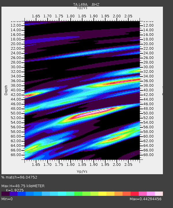
| Estimated Moho Depth: |
48.75 km |
| Estimated Crust Vp/Vs: |
1.92 |
| Assumed Crust Vp: |
6.483 km/s |
| Estimated Crust Vs: |
3.372 km/s |
| Estimated Crust Poisson's Ratio: |
0.31 |
|
| Radial Match: |
96.04752 % |
| Radial Bump: |
194 |
| Transverse Match: |
77.27649 % |
| Transverse Bump: |
400 |
| SOD ConfigId: |
626651 |
| Insert Time: |
2014-04-18 00:28:05.821 +0000 |
| GWidth: |
2.5 |
| Max Bumps: |
400 |
| Tol: |
0.001 |
|
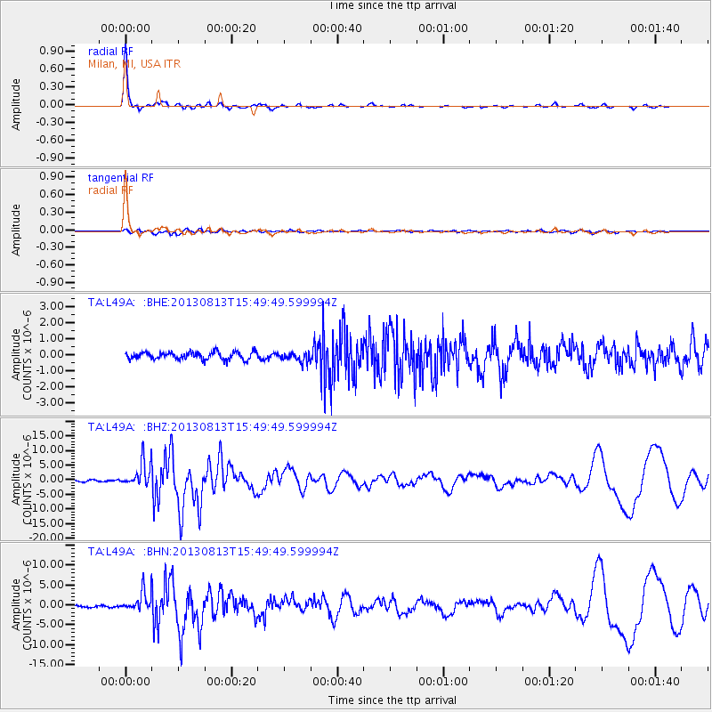
Signal To Noise
| Channel | StoN | STA | LTA |
| TA:L49A: :BHZ:20130813T15:49:49.599994Z | 14.970868 | 4.262061E-6 | 2.8469032E-7 |
| TA:L49A: :BHN:20130813T15:49:49.599994Z | 14.375615 | 2.442718E-6 | 1.6992094E-7 |
| TA:L49A: :BHE:20130813T15:49:49.599994Z | 1.2705383 | 2.889603E-7 | 2.2743139E-7 |
| Arrivals |
| Ps | 7.4 SECOND |
| PpPs | 20 SECOND |
| PsPs/PpSs | 28 SECOND |


