You are here: Home > Network List > TA - USArray Transportable Network (new EarthScope stations) Stations List
> Station L50A Kingsville, ON, CAN > Earthquake Result Viewer
L50A Kingsville, ON, CAN - Earthquake Result Viewer
| Earthquake location: |
South Of Panama |
| Earthquake latitude/longitude: |
5.8/-78.2 |
| Earthquake time(UTC): |
2013/08/13 (225) 15:43:15 GMT |
| Earthquake Depth: |
12 km |
| Earthquake Magnitude: |
6.7 MWW, 6.6 MWB, 6.7 MWW, 6.7 MWC, 6.7 MI |
| Earthquake Catalog/Contributor: |
NEIC PDE/NEIC COMCAT |
|
| Network: |
TA USArray Transportable Network (new EarthScope stations) |
| Station: |
L50A Kingsville, ON, CAN |
| Lat/Lon: |
42.04 N/82.81 W |
| Elevation: |
187 m |
|
| Distance: |
36.3 deg |
| Az: |
354.203 deg |
| Baz: |
172.246 deg |
| Ray Param: |
0.0767241 |
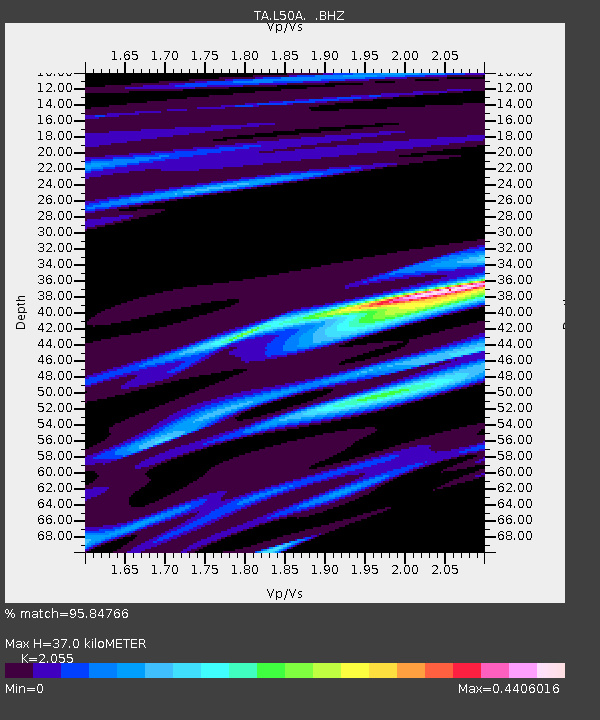
| Estimated Moho Depth: |
37.0 km |
| Estimated Crust Vp/Vs: |
2.06 |
| Assumed Crust Vp: |
6.483 km/s |
| Estimated Crust Vs: |
3.155 km/s |
| Estimated Crust Poisson's Ratio: |
0.34 |
|
| Radial Match: |
95.84766 % |
| Radial Bump: |
215 |
| Transverse Match: |
74.56324 % |
| Transverse Bump: |
400 |
| SOD ConfigId: |
626651 |
| Insert Time: |
2014-04-18 00:28:06.200 +0000 |
| GWidth: |
2.5 |
| Max Bumps: |
400 |
| Tol: |
0.001 |
|

Signal To Noise
| Channel | StoN | STA | LTA |
| TA:L50A: :BHZ:20130813T15:49:48.150012Z | 10.927304 | 3.2707478E-6 | 2.9931883E-7 |
| TA:L50A: :BHN:20130813T15:49:48.150012Z | 13.795183 | 1.9595598E-6 | 1.4204667E-7 |
| TA:L50A: :BHE:20130813T15:49:48.150012Z | 1.8274536 | 3.2556468E-7 | 1.7815209E-7 |
| Arrivals |
| Ps | 6.4 SECOND |
| PpPs | 16 SECOND |
| PsPs/PpSs | 23 SECOND |


