You are here: Home > Network List > TA - USArray Transportable Network (new EarthScope stations) Stations List
> Station L58A Harry Jones Memorial, Binghamton, NY, USA > Earthquake Result Viewer
L58A Harry Jones Memorial, Binghamton, NY, USA - Earthquake Result Viewer
| Earthquake location: |
South Of Panama |
| Earthquake latitude/longitude: |
5.8/-78.2 |
| Earthquake time(UTC): |
2013/08/13 (225) 15:43:15 GMT |
| Earthquake Depth: |
12 km |
| Earthquake Magnitude: |
6.7 MWW, 6.6 MWB, 6.7 MWW, 6.7 MWC, 6.7 MI |
| Earthquake Catalog/Contributor: |
NEIC PDE/NEIC COMCAT |
|
| Network: |
TA USArray Transportable Network (new EarthScope stations) |
| Station: |
L58A Harry Jones Memorial, Binghamton, NY, USA |
| Lat/Lon: |
42.04 N/75.85 W |
| Elevation: |
447 m |
|
| Distance: |
36.2 deg |
| Az: |
2.965 deg |
| Baz: |
183.963 deg |
| Ray Param: |
0.07681678 |
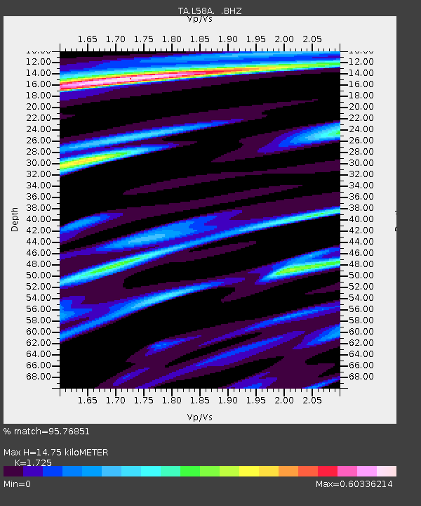
| Estimated Moho Depth: |
14.75 km |
| Estimated Crust Vp/Vs: |
1.73 |
| Assumed Crust Vp: |
6.419 km/s |
| Estimated Crust Vs: |
3.721 km/s |
| Estimated Crust Poisson's Ratio: |
0.25 |
|
| Radial Match: |
95.76851 % |
| Radial Bump: |
210 |
| Transverse Match: |
84.745415 % |
| Transverse Bump: |
287 |
| SOD ConfigId: |
626651 |
| Insert Time: |
2014-04-18 00:28:17.932 +0000 |
| GWidth: |
2.5 |
| Max Bumps: |
400 |
| Tol: |
0.001 |
|
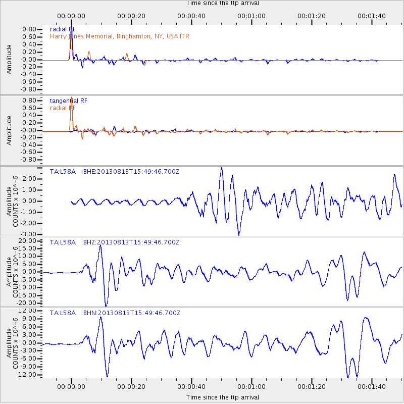
Signal To Noise
| Channel | StoN | STA | LTA |
| TA:L58A: :BHZ:20130813T15:49:46.700Z | 8.645185 | 1.6607294E-6 | 1.9209875E-7 |
| TA:L58A: :BHN:20130813T15:49:46.700Z | 6.247052 | 9.639059E-7 | 1.5429772E-7 |
| TA:L58A: :BHE:20130813T15:49:46.700Z | 1.0095612 | 1.6738801E-7 | 1.6580275E-7 |
| Arrivals |
| Ps | 1.8 SECOND |
| PpPs | 5.8 SECOND |
| PsPs/PpSs | 7.6 SECOND |


