You are here: Home > Network List > TA - USArray Transportable Network (new EarthScope stations) Stations List
> Station M59A Waymart, PA, USA > Earthquake Result Viewer
M59A Waymart, PA, USA - Earthquake Result Viewer
| Earthquake location: |
South Of Panama |
| Earthquake latitude/longitude: |
5.8/-78.2 |
| Earthquake time(UTC): |
2013/08/13 (225) 15:43:15 GMT |
| Earthquake Depth: |
12 km |
| Earthquake Magnitude: |
6.7 MWW, 6.6 MWB, 6.7 MWW, 6.7 MWC, 6.7 MI |
| Earthquake Catalog/Contributor: |
NEIC PDE/NEIC COMCAT |
|
| Network: |
TA USArray Transportable Network (new EarthScope stations) |
| Station: |
M59A Waymart, PA, USA |
| Lat/Lon: |
41.54 N/75.43 W |
| Elevation: |
471 m |
|
| Distance: |
35.7 deg |
| Az: |
3.561 deg |
| Baz: |
184.723 deg |
| Ray Param: |
0.07707674 |
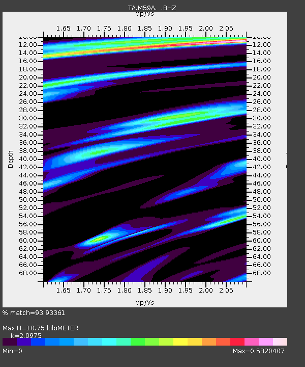
| Estimated Moho Depth: |
10.75 km |
| Estimated Crust Vp/Vs: |
2.10 |
| Assumed Crust Vp: |
6.283 km/s |
| Estimated Crust Vs: |
2.996 km/s |
| Estimated Crust Poisson's Ratio: |
0.35 |
|
| Radial Match: |
93.93361 % |
| Radial Bump: |
264 |
| Transverse Match: |
82.42011 % |
| Transverse Bump: |
282 |
| SOD ConfigId: |
626651 |
| Insert Time: |
2014-04-18 00:29:17.508 +0000 |
| GWidth: |
2.5 |
| Max Bumps: |
400 |
| Tol: |
0.001 |
|
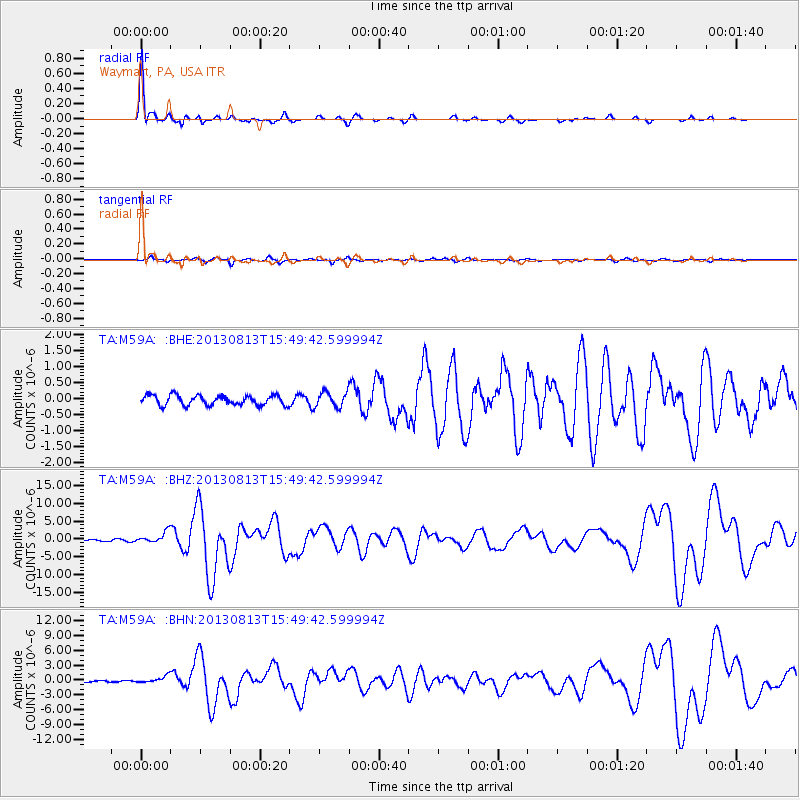
Signal To Noise
| Channel | StoN | STA | LTA |
| TA:M59A: :BHZ:20130813T15:49:42.599994Z | 9.316232 | 1.5604061E-6 | 1.6749327E-7 |
| TA:M59A: :BHN:20130813T15:49:42.599994Z | 4.331647 | 7.1132894E-7 | 1.6421673E-7 |
| TA:M59A: :BHE:20130813T15:49:42.599994Z | 1.5482279 | 2.3587575E-7 | 1.5235207E-7 |
| Arrivals |
| Ps | 2.0 SECOND |
| PpPs | 5.0 SECOND |
| PsPs/PpSs | 7.0 SECOND |


