You are here: Home > Network List > TA - USArray Transportable Network (new EarthScope stations) Stations List
> Station M61A Granite Springs, NY, USA > Earthquake Result Viewer
M61A Granite Springs, NY, USA - Earthquake Result Viewer
| Earthquake location: |
South Of Panama |
| Earthquake latitude/longitude: |
5.8/-78.2 |
| Earthquake time(UTC): |
2013/08/13 (225) 15:43:15 GMT |
| Earthquake Depth: |
12 km |
| Earthquake Magnitude: |
6.7 MWW, 6.6 MWB, 6.7 MWW, 6.7 MWC, 6.7 MI |
| Earthquake Catalog/Contributor: |
NEIC PDE/NEIC COMCAT |
|
| Network: |
TA USArray Transportable Network (new EarthScope stations) |
| Station: |
M61A Granite Springs, NY, USA |
| Lat/Lon: |
41.31 N/73.77 W |
| Elevation: |
190 m |
|
| Distance: |
35.6 deg |
| Az: |
5.739 deg |
| Baz: |
187.59 deg |
| Ray Param: |
0.07712804 |
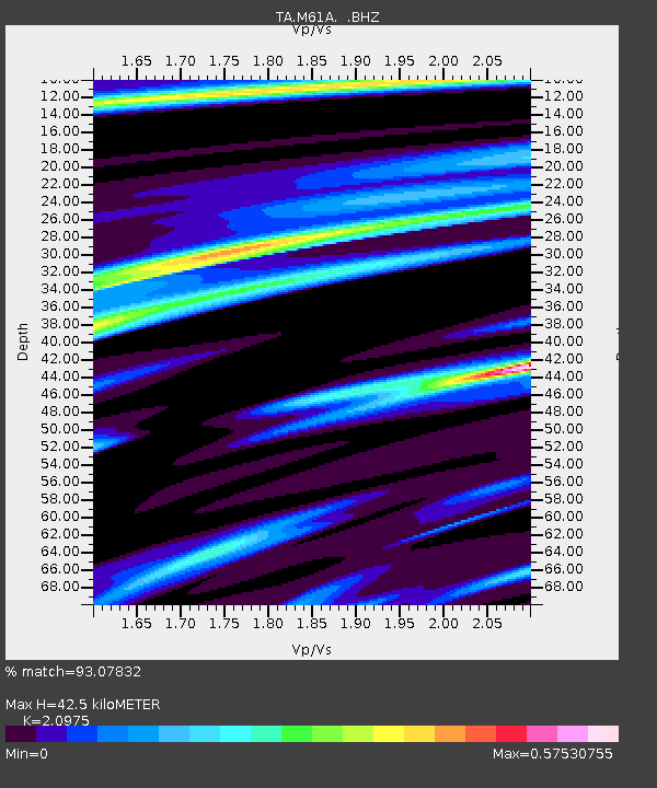
| Estimated Moho Depth: |
42.5 km |
| Estimated Crust Vp/Vs: |
2.10 |
| Assumed Crust Vp: |
6.472 km/s |
| Estimated Crust Vs: |
3.086 km/s |
| Estimated Crust Poisson's Ratio: |
0.35 |
|
| Radial Match: |
93.07832 % |
| Radial Bump: |
156 |
| Transverse Match: |
74.69352 % |
| Transverse Bump: |
313 |
| SOD ConfigId: |
626651 |
| Insert Time: |
2014-04-18 00:29:20.766 +0000 |
| GWidth: |
2.5 |
| Max Bumps: |
400 |
| Tol: |
0.001 |
|

Signal To Noise
| Channel | StoN | STA | LTA |
| TA:M61A: :BHZ:20130813T15:49:41.798999Z | 9.993864 | 1.2793771E-6 | 1.2801625E-7 |
| TA:M61A: :BHN:20130813T15:49:41.798999Z | 8.302199 | 9.058675E-7 | 1.09111745E-7 |
| TA:M61A: :BHE:20130813T15:49:41.798999Z | 0.9279297 | 1.4040523E-7 | 1.513102E-7 |
| Arrivals |
| Ps | 7.7 SECOND |
| PpPs | 19 SECOND |
| PsPs/PpSs | 27 SECOND |


