You are here: Home > Network List > TA - USArray Transportable Network (new EarthScope stations) Stations List
> Station R53A Hurricane, WV, USA > Earthquake Result Viewer
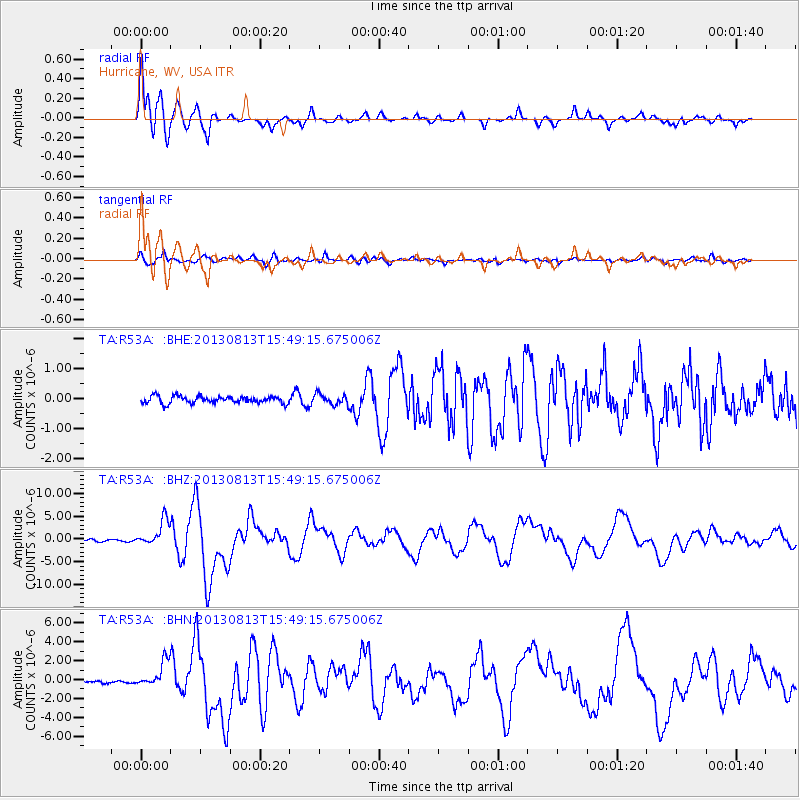
R53A Hurricane, WV, USA - Earthquake Result Viewer

| Earthquake location: |
South Of Panama |
| Earthquake latitude/longitude: |
5.8/-78.2 |
| Earthquake time(UTC): |
2013/08/13 (225) 15:43:15 GMT |
| Earthquake Depth: |
12 km |
| Earthquake Magnitude: |
6.7 MWW, 6.6 MWB, 6.7 MWW, 6.7 MWC, 6.7 MI |
| Earthquake Catalog/Contributor: |
NEIC PDE/NEIC COMCAT |
|
| Network: |
TA USArray Transportable Network (new EarthScope stations) |
| Station: |
R53A Hurricane, WV, USA |
| Lat/Lon: |
38.33 N/81.95 W |
| Elevation: |
294 m |
|
| Distance: |
32.6 deg |
| Az: |
354.518 deg |
| Baz: |
173.058 deg |
| Ray Param: |
0.07858418 |
| Estimated Moho Depth: |
20.75 km |
| Estimated Crust Vp/Vs: |
1.75 |
| Assumed Crust Vp: |
6.207 km/s |
| Estimated Crust Vs: |
3.542 km/s |
| Estimated Crust Poisson's Ratio: |
0.26 |
|
| Radial Match: |
92.870834 % |
| Radial Bump: |
400 |
| Transverse Match: |
85.37954 % |
| Transverse Bump: |
400 |
| SOD ConfigId: |
626651 |
| Insert Time: |
2014-04-18 00:33:16.601 +0000 |
| GWidth: |
2.5 |
| Max Bumps: |
400 |
| Tol: |
0.001 |
|
Signal To Noise
| Channel | StoN | STA | LTA |
| TA:R53A: :BHZ:20130813T15:49:15.675006Z | 11.366474 | 2.803017E-6 | 2.4660392E-7 |
| TA:R53A: :BHN:20130813T15:49:15.675006Z | 8.362986 | 1.3617366E-6 | 1.6282901E-7 |
| TA:R53A: :BHE:20130813T15:49:15.675006Z | 1.4589525 | 1.6929557E-7 | 1.1603912E-7 |
| Arrivals |
| Ps | 2.7 SECOND |
| PpPs | 8.5 SECOND |
| PsPs/PpSs | 11 SECOND |


