You are here: Home > Network List > TA - USArray Transportable Network (new EarthScope stations) Stations List
> Station R55A Marlinton, WV, USA > Earthquake Result Viewer
R55A Marlinton, WV, USA - Earthquake Result Viewer

| Earthquake location: |
South Of Panama |
| Earthquake latitude/longitude: |
5.8/-78.2 |
| Earthquake time(UTC): |
2013/08/13 (225) 15:43:15 GMT |
| Earthquake Depth: |
12 km |
| Earthquake Magnitude: |
6.7 MWW, 6.6 MWB, 6.7 MWW, 6.7 MWC, 6.7 MI |
| Earthquake Catalog/Contributor: |
NEIC PDE/NEIC COMCAT |
|
| Network: |
TA USArray Transportable Network (new EarthScope stations) |
| Station: |
R55A Marlinton, WV, USA |
| Lat/Lon: |
38.28 N/80.12 W |
| Elevation: |
833 m |
|
| Distance: |
32.4 deg |
| Az: |
357.181 deg |
| Baz: |
176.435 deg |
| Ray Param: |
0.07866069 |
| Estimated Moho Depth: |
10.0 km |
| Estimated Crust Vp/Vs: |
1.60 |
| Assumed Crust Vp: |
6.207 km/s |
| Estimated Crust Vs: |
3.879 km/s |
| Estimated Crust Poisson's Ratio: |
0.18 |
|
| Radial Match: |
95.55058 % |
| Radial Bump: |
298 |
| Transverse Match: |
82.06625 % |
| Transverse Bump: |
400 |
| SOD ConfigId: |
626651 |
| Insert Time: |
2014-04-18 00:33:20.101 +0000 |
| GWidth: |
2.5 |
| Max Bumps: |
400 |
| Tol: |
0.001 |
|
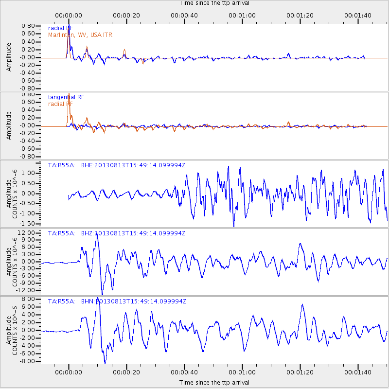
Signal To Noise
| Channel | StoN | STA | LTA |
| TA:R55A: :BHZ:20130813T15:49:14.099994Z | 11.644544 | 2.107373E-6 | 1.8097514E-7 |
| TA:R55A: :BHN:20130813T15:49:14.099994Z | 8.472922 | 1.0869562E-6 | 1.2828586E-7 |
| TA:R55A: :BHE:20130813T15:49:14.099994Z | 1.0393951 | 1.3123429E-7 | 1.2626025E-7 |
| Arrivals |
| Ps | 1.0 SECOND |
| PpPs | 3.9 SECOND |
| PsPs/PpSs | 4.9 SECOND |


