You are here: Home > Network List > TA - USArray Transportable Network (new EarthScope stations) Stations List
> Station S54A Dingess, Beckley, WV, USA > Earthquake Result Viewer
S54A Dingess, Beckley, WV, USA - Earthquake Result Viewer
| Earthquake location: |
South Of Panama |
| Earthquake latitude/longitude: |
5.8/-78.2 |
| Earthquake time(UTC): |
2013/08/13 (225) 15:43:15 GMT |
| Earthquake Depth: |
12 km |
| Earthquake Magnitude: |
6.7 MWW, 6.6 MWB, 6.7 MWW, 6.7 MWC, 6.7 MI |
| Earthquake Catalog/Contributor: |
NEIC PDE/NEIC COMCAT |
|
| Network: |
TA USArray Transportable Network (new EarthScope stations) |
| Station: |
S54A Dingess, Beckley, WV, USA |
| Lat/Lon: |
37.80 N/81.31 W |
| Elevation: |
636 m |
|
| Distance: |
32.0 deg |
| Az: |
355.347 deg |
| Baz: |
174.151 deg |
| Ray Param: |
0.078832135 |
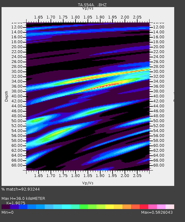
| Estimated Moho Depth: |
36.0 km |
| Estimated Crust Vp/Vs: |
1.91 |
| Assumed Crust Vp: |
6.159 km/s |
| Estimated Crust Vs: |
3.229 km/s |
| Estimated Crust Poisson's Ratio: |
0.31 |
|
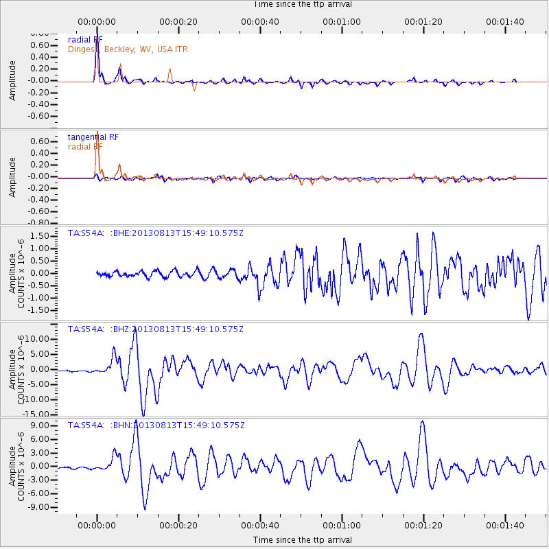
| Radial Match: |
92.93244 % |
| Radial Bump: |
307 |
| Transverse Match: |
69.745514 % |
| Transverse Bump: |
400 |
| SOD ConfigId: |
626651 |
| Insert Time: |
2014-04-18 00:33:59.625 +0000 |
| GWidth: |
2.5 |
| Max Bumps: |
400 |
| Tol: |
0.001 |
|
Signal To Noise
| Channel | StoN | STA | LTA |
| TA:S54A: :BHZ:20130813T15:49:10.575Z | 16.452354 | 2.9037828E-6 | 1.7649648E-7 |
| TA:S54A: :BHN:20130813T15:49:10.575Z | 11.550837 | 1.6239129E-6 | 1.4058834E-7 |
| TA:S54A: :BHE:20130813T15:49:10.575Z | 1.3789515 | 1.4918434E-7 | 1.08186796E-7 |
| Arrivals |
| Ps | 5.7 SECOND |
| PpPs | 16 SECOND |
| PsPs/PpSs | 22 SECOND |


