You are here: Home > Network List > TA - USArray Transportable Network (new EarthScope stations) Stations List
> Station V48A Smith Brothers Farm, Spring Hill, TN, USA > Earthquake Result Viewer
V48A Smith Brothers Farm, Spring Hill, TN, USA - Earthquake Result Viewer
| Earthquake location: |
South Of Panama |
| Earthquake latitude/longitude: |
5.8/-78.2 |
| Earthquake time(UTC): |
2013/08/13 (225) 15:43:15 GMT |
| Earthquake Depth: |
12 km |
| Earthquake Magnitude: |
6.7 MWW, 6.6 MWB, 6.7 MWW, 6.7 MWC, 6.7 MI |
| Earthquake Catalog/Contributor: |
NEIC PDE/NEIC COMCAT |
|
| Network: |
TA USArray Transportable Network (new EarthScope stations) |
| Station: |
V48A Smith Brothers Farm, Spring Hill, TN, USA |
| Lat/Lon: |
35.74 N/86.82 W |
| Elevation: |
278 m |
|
| Distance: |
30.9 deg |
| Az: |
346.245 deg |
| Baz: |
163.094 deg |
| Ray Param: |
0.07921862 |
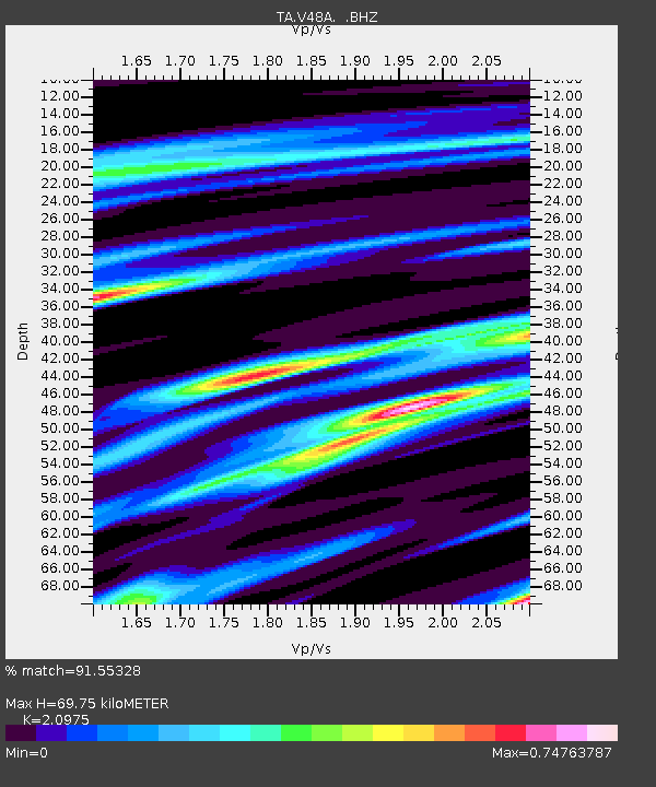
| Estimated Moho Depth: |
69.75 km |
| Estimated Crust Vp/Vs: |
2.10 |
| Assumed Crust Vp: |
6.476 km/s |
| Estimated Crust Vs: |
3.087 km/s |
| Estimated Crust Poisson's Ratio: |
0.35 |
|
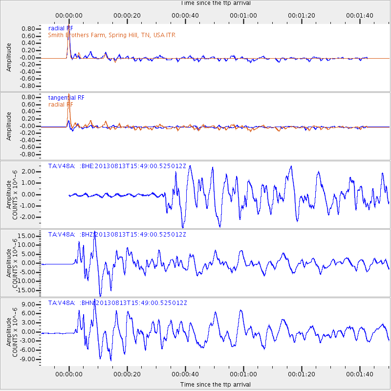
| Radial Match: |
91.55328 % |
| Radial Bump: |
313 |
| Transverse Match: |
84.66165 % |
| Transverse Bump: |
400 |
| SOD ConfigId: |
626651 |
| Insert Time: |
2014-04-18 00:35:50.793 +0000 |
| GWidth: |
2.5 |
| Max Bumps: |
400 |
| Tol: |
0.001 |
|
Signal To Noise
| Channel | StoN | STA | LTA |
| TA:V48A: :BHZ:20130813T15:49:00.525012Z | 43.3141 | 4.062069E-6 | 9.378168E-8 |
| TA:V48A: :BHN:20130813T15:49:00.525012Z | 26.823544 | 2.4065143E-6 | 8.97165E-8 |
| TA:V48A: :BHE:20130813T15:49:00.525012Z | 6.7731996 | 5.6857596E-7 | 8.3944954E-8 |
| Arrivals |
| Ps | 13 SECOND |
| PpPs | 31 SECOND |
| PsPs/PpSs | 44 SECOND |


