You are here: Home > Network List > TA - USArray Transportable Network (new EarthScope stations) Stations List
> Station V49A McMinnville, TN, USA > Earthquake Result Viewer
V49A McMinnville, TN, USA - Earthquake Result Viewer
| Earthquake location: |
South Of Panama |
| Earthquake latitude/longitude: |
5.8/-78.2 |
| Earthquake time(UTC): |
2013/08/13 (225) 15:43:15 GMT |
| Earthquake Depth: |
12 km |
| Earthquake Magnitude: |
6.7 MWW, 6.6 MWB, 6.7 MWW, 6.7 MWC, 6.7 MI |
| Earthquake Catalog/Contributor: |
NEIC PDE/NEIC COMCAT |
|
| Network: |
TA USArray Transportable Network (new EarthScope stations) |
| Station: |
V49A McMinnville, TN, USA |
| Lat/Lon: |
35.77 N/85.90 W |
| Elevation: |
329 m |
|
| Distance: |
30.7 deg |
| Az: |
347.664 deg |
| Baz: |
164.848 deg |
| Ray Param: |
0.07926621 |
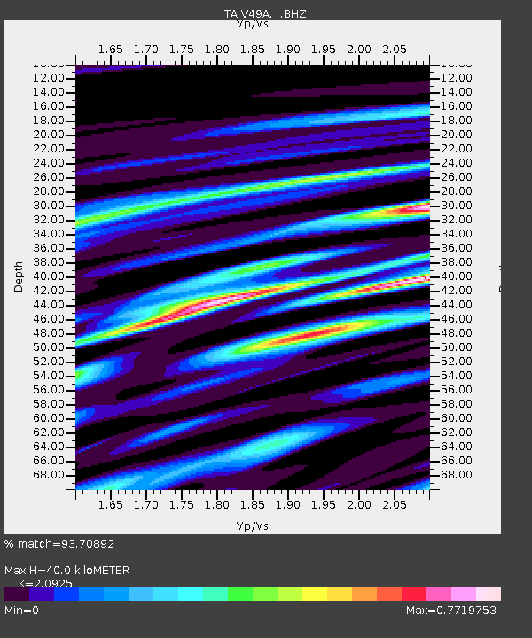
| Estimated Moho Depth: |
40.0 km |
| Estimated Crust Vp/Vs: |
2.09 |
| Assumed Crust Vp: |
6.35 km/s |
| Estimated Crust Vs: |
3.035 km/s |
| Estimated Crust Poisson's Ratio: |
0.35 |
|
| Radial Match: |
93.70892 % |
| Radial Bump: |
343 |
| Transverse Match: |
77.383736 % |
| Transverse Bump: |
400 |
| SOD ConfigId: |
626651 |
| Insert Time: |
2014-04-18 00:35:51.243 +0000 |
| GWidth: |
2.5 |
| Max Bumps: |
400 |
| Tol: |
0.001 |
|
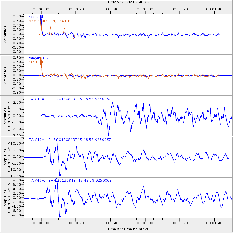
Signal To Noise
| Channel | StoN | STA | LTA |
| TA:V49A: :BHZ:20130813T15:48:58.925006Z | 38.2794 | 3.4343443E-6 | 8.971782E-8 |
| TA:V49A: :BHN:20130813T15:48:58.925006Z | 20.376808 | 2.144432E-6 | 1.05238854E-7 |
| TA:V49A: :BHE:20130813T15:48:58.925006Z | 4.836344 | 5.502917E-7 | 1.137826E-7 |
| Arrivals |
| Ps | 7.4 SECOND |
| PpPs | 18 SECOND |
| PsPs/PpSs | 26 SECOND |


