You are here: Home > Network List > US - United States National Seismic Network Stations List
> Station ACSO Alum Creek State Park, Ohio, USA > Earthquake Result Viewer
ACSO Alum Creek State Park, Ohio, USA - Earthquake Result Viewer
| Earthquake location: |
South Of Panama |
| Earthquake latitude/longitude: |
5.8/-78.2 |
| Earthquake time(UTC): |
2013/08/13 (225) 15:43:15 GMT |
| Earthquake Depth: |
12 km |
| Earthquake Magnitude: |
6.7 MWW, 6.6 MWB, 6.7 MWW, 6.7 MWC, 6.7 MI |
| Earthquake Catalog/Contributor: |
NEIC PDE/NEIC COMCAT |
|
| Network: |
US United States National Seismic Network |
| Station: |
ACSO Alum Creek State Park, Ohio, USA |
| Lat/Lon: |
40.23 N/82.98 W |
| Elevation: |
288 m |
|
| Distance: |
34.6 deg |
| Az: |
353.543 deg |
| Baz: |
171.595 deg |
| Ray Param: |
0.07766559 |
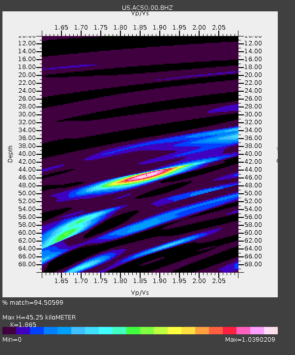
| Estimated Moho Depth: |
45.25 km |
| Estimated Crust Vp/Vs: |
1.87 |
| Assumed Crust Vp: |
6.498 km/s |
| Estimated Crust Vs: |
3.484 km/s |
| Estimated Crust Poisson's Ratio: |
0.30 |
|
| Radial Match: |
94.50599 % |
| Radial Bump: |
227 |
| Transverse Match: |
79.26613 % |
| Transverse Bump: |
400 |
| SOD ConfigId: |
626651 |
| Insert Time: |
2014-04-18 00:37:07.532 +0000 |
| GWidth: |
2.5 |
| Max Bumps: |
400 |
| Tol: |
0.001 |
|
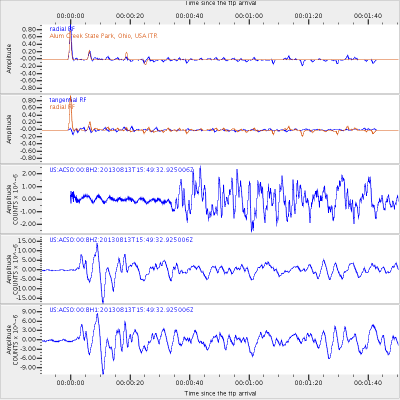
Signal To Noise
| Channel | StoN | STA | LTA |
| US:ACSO:00:BHZ:20130813T15:49:32.925006Z | 23.572578 | 2.8594243E-6 | 1.2130299E-7 |
| US:ACSO:00:BH1:20130813T15:49:32.925006Z | 12.351006 | 1.818868E-6 | 1.4726477E-7 |
| US:ACSO:00:BH2:20130813T15:49:32.925006Z | 2.2660549 | 3.8841975E-7 | 1.714079E-7 |
| Arrivals |
| Ps | 6.5 SECOND |
| PpPs | 19 SECOND |
| PsPs/PpSs | 25 SECOND |


