You are here: Home > Network List > US - United States National Seismic Network Stations List
> Station LONY Lake Ozonia, New York, USA > Earthquake Result Viewer
LONY Lake Ozonia, New York, USA - Earthquake Result Viewer
| Earthquake location: |
South Of Panama |
| Earthquake latitude/longitude: |
5.8/-78.2 |
| Earthquake time(UTC): |
2013/08/13 (225) 15:43:15 GMT |
| Earthquake Depth: |
12 km |
| Earthquake Magnitude: |
6.7 MWW, 6.6 MWB, 6.7 MWW, 6.7 MWC, 6.7 MI |
| Earthquake Catalog/Contributor: |
NEIC PDE/NEIC COMCAT |
|
| Network: |
US United States National Seismic Network |
| Station: |
LONY Lake Ozonia, New York, USA |
| Lat/Lon: |
44.62 N/74.58 W |
| Elevation: |
440 m |
|
| Distance: |
38.8 deg |
| Az: |
4.121 deg |
| Baz: |
185.747 deg |
| Ray Param: |
0.07533498 |
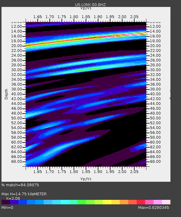
| Estimated Moho Depth: |
14.75 km |
| Estimated Crust Vp/Vs: |
2.08 |
| Assumed Crust Vp: |
6.419 km/s |
| Estimated Crust Vs: |
3.086 km/s |
| Estimated Crust Poisson's Ratio: |
0.35 |
|
| Radial Match: |
94.09875 % |
| Radial Bump: |
248 |
| Transverse Match: |
86.607956 % |
| Transverse Bump: |
282 |
| SOD ConfigId: |
626651 |
| Insert Time: |
2014-04-18 00:38:26.953 +0000 |
| GWidth: |
2.5 |
| Max Bumps: |
400 |
| Tol: |
0.001 |
|
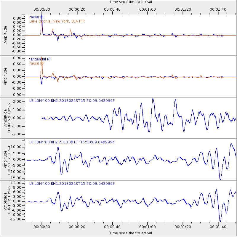
Signal To Noise
| Channel | StoN | STA | LTA |
| US:LONY:00:BHZ:20130813T15:50:09.048999Z | 8.261059 | 1.3938642E-6 | 1.6872706E-7 |
| US:LONY:00:BH1:20130813T15:50:09.048999Z | 8.275923 | 9.560772E-7 | 1.1552515E-7 |
| US:LONY:00:BH2:20130813T15:50:09.048999Z | 1.269907 | 1.864519E-7 | 1.4682327E-7 |
| Arrivals |
| Ps | 2.6 SECOND |
| PpPs | 6.7 SECOND |
| PsPs/PpSs | 9.3 SECOND |


