You are here: Home > Network List > US - United States National Seismic Network Stations List
> Station OGNE Ogallala, Nebraska, USA > Earthquake Result Viewer
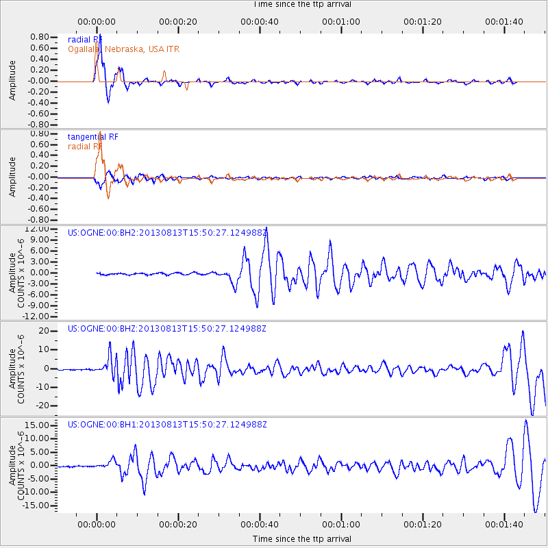
OGNE Ogallala, Nebraska, USA - Earthquake Result Viewer
| Earthquake location: |
South Of Panama |
| Earthquake latitude/longitude: |
5.8/-78.2 |
| Earthquake time(UTC): |
2013/08/13 (225) 15:43:15 GMT |
| Earthquake Depth: |
12 km |
| Earthquake Magnitude: |
6.7 MWW, 6.6 MWB, 6.7 MWW, 6.7 MWC, 6.7 MI |
| Earthquake Catalog/Contributor: |
NEIC PDE/NEIC COMCAT |
|
| Network: |
US United States National Seismic Network |
| Station: |
OGNE Ogallala, Nebraska, USA |
| Lat/Lon: |
40.95 N/102.03 W |
| Elevation: |
0.0 m |
|
| Distance: |
41.0 deg |
| Az: |
332.19 deg |
| Baz: |
142.208 deg |
| Ray Param: |
0.07405839 |
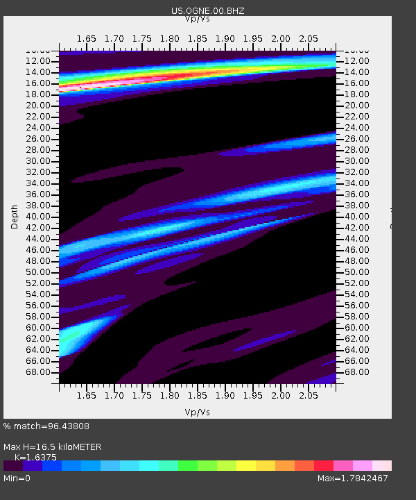
| Estimated Moho Depth: |
16.5 km |
| Estimated Crust Vp/Vs: |
1.64 |
| Assumed Crust Vp: |
6.483 km/s |
| Estimated Crust Vs: |
3.959 km/s |
| Estimated Crust Poisson's Ratio: |
0.20 |
|
| Radial Match: |
96.43808 % |
| Radial Bump: |
275 |
| Transverse Match: |
83.348694 % |
| Transverse Bump: |
364 |
| SOD ConfigId: |
626651 |
| Insert Time: |
2014-04-18 00:38:47.578 +0000 |
| GWidth: |
2.5 |
| Max Bumps: |
400 |
| Tol: |
0.001 |
|
Signal To Noise
| Channel | StoN | STA | LTA |
| US:OGNE:00:BHZ:20130813T15:50:27.124988Z | 33.995804 | 5.0020435E-6 | 1.4713709E-7 |
| US:OGNE:00:BH1:20130813T15:50:27.124988Z | 7.232509 | 1.6054499E-6 | 2.219769E-7 |
| US:OGNE:00:BH2:20130813T15:50:27.124988Z | 8.398742 | 2.0054656E-6 | 2.3878167E-7 |
| Arrivals |
| Ps | 1.8 SECOND |
| PpPs | 6.2 SECOND |
| PsPs/PpSs | 8.0 SECOND |


