You are here: Home > Network List > UU - University of Utah Regional Network Stations List
> Station LCMT Little Creek Mountain, UT, USA > Earthquake Result Viewer
LCMT Little Creek Mountain, UT, USA - Earthquake Result Viewer
| Earthquake location: |
South Of Panama |
| Earthquake latitude/longitude: |
5.8/-78.2 |
| Earthquake time(UTC): |
2013/08/13 (225) 15:43:15 GMT |
| Earthquake Depth: |
12 km |
| Earthquake Magnitude: |
6.7 MWW, 6.6 MWB, 6.7 MWW, 6.7 MWC, 6.7 MI |
| Earthquake Catalog/Contributor: |
NEIC PDE/NEIC COMCAT |
|
| Network: |
UU University of Utah Regional Network |
| Station: |
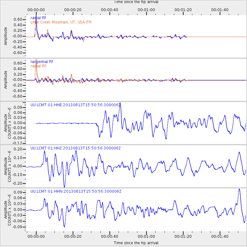
LCMT Little Creek Mountain, UT, USA |
| Lat/Lon: |
37.01 N/113.24 W |
| Elevation: |
1411 m |
|
| Distance: |
44.6 deg |
| Az: |
319.117 deg |
| Baz: |
125.551 deg |
| Ray Param: |
0.07180801 |
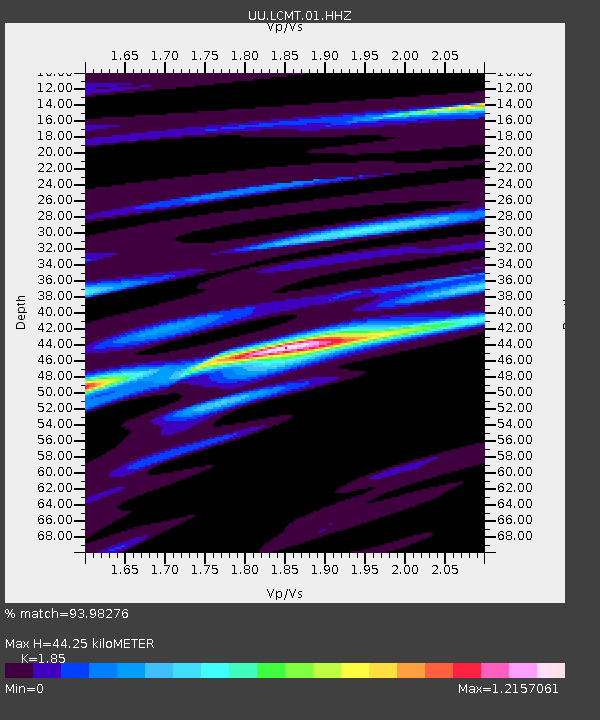
| Estimated Moho Depth: |
44.25 km |
| Estimated Crust Vp/Vs: |
1.85 |
| Assumed Crust Vp: |
6.194 km/s |
| Estimated Crust Vs: |
3.348 km/s |
| Estimated Crust Poisson's Ratio: |
0.29 |
|
| Radial Match: |
93.98276 % |
| Radial Bump: |
271 |
| Transverse Match: |
77.36563 % |
| Transverse Bump: |
400 |
| SOD ConfigId: |
626651 |
| Insert Time: |
2014-04-18 00:39:41.570 +0000 |
| GWidth: |
2.5 |
| Max Bumps: |
400 |
| Tol: |
0.001 |
|
Signal To Noise
| Channel | StoN | STA | LTA |
| UU:LCMT:01:HHZ:20130813T15:50:56.300006Z | 25.768967 | 6.305619E-8 | 2.4469815E-9 |
| UU:LCMT:01:HHN:20130813T15:50:56.300006Z | 21.402555 | 2.131849E-8 | 9.960721E-10 |
| UU:LCMT:01:HHE:20130813T15:50:56.300006Z | 23.430256 | 2.7122336E-8 | 1.1575775E-9 |
| Arrivals |
| Ps | 6.4 SECOND |
| PpPs | 19 SECOND |
| PsPs/PpSs | 26 SECOND |


