You are here: Home > Network List > UU - University of Utah Regional Network Stations List
> Station NLU North Lily, UT, USA > Earthquake Result Viewer
NLU North Lily, UT, USA - Earthquake Result Viewer
| Earthquake location: |
South Of Panama |
| Earthquake latitude/longitude: |
5.8/-78.2 |
| Earthquake time(UTC): |
2013/08/13 (225) 15:43:15 GMT |
| Earthquake Depth: |
12 km |
| Earthquake Magnitude: |
6.7 MWW, 6.6 MWB, 6.7 MWW, 6.7 MWC, 6.7 MI |
| Earthquake Catalog/Contributor: |
NEIC PDE/NEIC COMCAT |
|
| Network: |
UU University of Utah Regional Network |
| Station: |
NLU North Lily, UT, USA |
| Lat/Lon: |
39.95 N/112.07 W |
| Elevation: |
2036 m |
|
| Distance: |
45.7 deg |
| Az: |
323.198 deg |
| Baz: |
129.156 deg |
| Ray Param: |
0.0711261 |
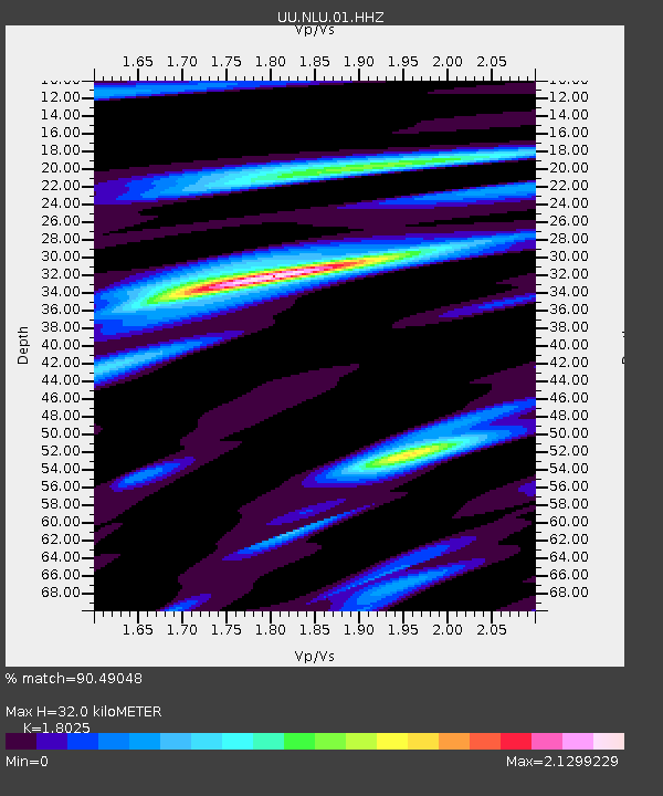
| Estimated Moho Depth: |
32.0 km |
| Estimated Crust Vp/Vs: |
1.80 |
| Assumed Crust Vp: |
6.276 km/s |
| Estimated Crust Vs: |
3.482 km/s |
| Estimated Crust Poisson's Ratio: |
0.28 |
|
| Radial Match: |
90.49048 % |
| Radial Bump: |
400 |
| Transverse Match: |
79.32905 % |
| Transverse Bump: |
400 |
| SOD ConfigId: |
626651 |
| Insert Time: |
2014-04-18 00:39:53.858 +0000 |
| GWidth: |
2.5 |
| Max Bumps: |
400 |
| Tol: |
0.001 |
|

Signal To Noise
| Channel | StoN | STA | LTA |
| UU:NLU:01:HHZ:20130813T15:51:04.664996Z | 20.595114 | 6.4271056E-8 | 3.1206941E-9 |
| UU:NLU:01:HHN:20130813T15:51:04.664996Z | 9.33719 | 1.868195E-8 | 2.0008109E-9 |
| UU:NLU:01:HHE:20130813T15:51:04.664996Z | 11.868937 | 3.232653E-8 | 2.7236247E-9 |
| Arrivals |
| Ps | 4.3 SECOND |
| PpPs | 13 SECOND |
| PsPs/PpSs | 18 SECOND |


