You are here: Home > Network List > UW - Pacific Northwest Regional Seismic Network Stations List
> Station LCCR Mulino, OR, USA > Earthquake Result Viewer
LCCR Mulino, OR, USA - Earthquake Result Viewer
| Earthquake location: |
South Of Panama |
| Earthquake latitude/longitude: |
5.8/-78.2 |
| Earthquake time(UTC): |
2013/08/13 (225) 15:43:15 GMT |
| Earthquake Depth: |
12 km |
| Earthquake Magnitude: |
6.7 MWW, 6.6 MWB, 6.7 MWW, 6.7 MWC, 6.7 MI |
| Earthquake Catalog/Contributor: |
NEIC PDE/NEIC COMCAT |
|
| Network: |
UW Pacific Northwest Regional Seismic Network |
| Station: |
LCCR Mulino, OR, USA |
| Lat/Lon: |
45.21 N/122.48 W |
| Elevation: |
273 m |
|
| Distance: |
55.0 deg |
| Az: |
322.924 deg |
| Baz: |
121.949 deg |
| Ray Param: |
0.06511194 |
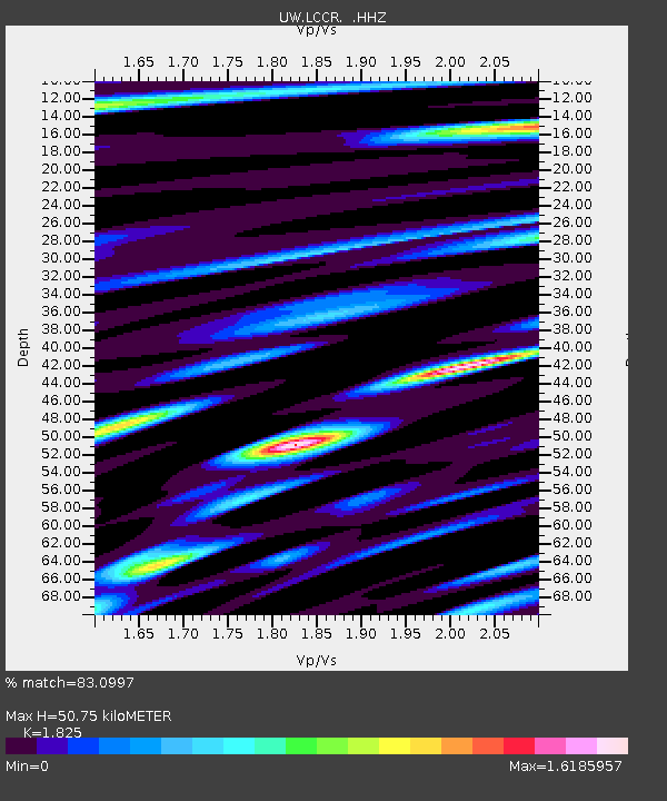
| Estimated Moho Depth: |
50.75 km |
| Estimated Crust Vp/Vs: |
1.83 |
| Assumed Crust Vp: |
6.566 km/s |
| Estimated Crust Vs: |
3.598 km/s |
| Estimated Crust Poisson's Ratio: |
0.29 |
|
| Radial Match: |
83.0997 % |
| Radial Bump: |
400 |
| Transverse Match: |
76.941795 % |
| Transverse Bump: |
400 |
| SOD ConfigId: |
626651 |
| Insert Time: |
2014-04-18 00:40:51.894 +0000 |
| GWidth: |
2.5 |
| Max Bumps: |
400 |
| Tol: |
0.001 |
|

Signal To Noise
| Channel | StoN | STA | LTA |
| UW:LCCR: :HHZ:20130813T15:52:14.887988Z | 15.520008 | 1.8008077E-6 | 1.16031366E-7 |
| UW:LCCR: :HHN:20130813T15:52:14.887988Z | 3.619529 | 5.178761E-7 | 1.4307832E-7 |
| UW:LCCR: :HHE:20130813T15:52:14.887988Z | 6.214076 | 7.694316E-7 | 1.2382075E-7 |
| Arrivals |
| Ps | 6.7 SECOND |
| PpPs | 21 SECOND |
| PsPs/PpSs | 27 SECOND |


