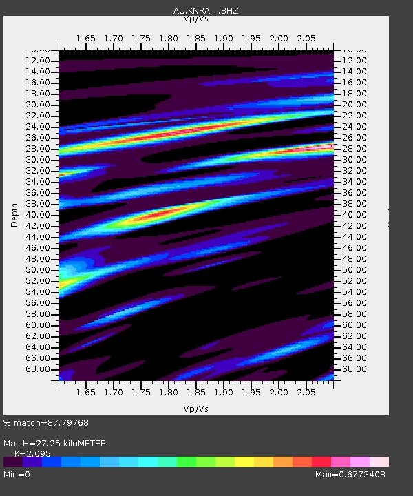
KNRA Kunnunarra, Western Australia - Earthquake Result Viewer

Earthquake location: Cook Strait, New Zealand
Earthquake latitude/longitude: -41.7/174.2
Earthquake time(UTC): 2013/08/16 (228) 02:31:05 GMT
Earthquake Depth: 8.2 km
Earthquake Magnitude: 6.5 MWW, 6.5 MWB, 6.5 MWC, 6.5 MWW, 6.6 MWC, 6.8 MI
Earthquake Catalog/Contributor: NEIC PDE/NEIC COMCAT
Network: AU Australian Seismological Centre
Station: KNRA Kunnunarra, Western Australia
Lat/Lon: 15.68 S/128.76 E
Elevation: 101 m
Distance: 46.8 deg
Az: 289.857 deg
Baz: 133.046 deg
Ray Param: 0.07041266
Estimated Moho Depth: 27.25 km
Estimated Crust Vp/Vs: 2.10
Assumed Crust Vp: 6.397 km/s
Estimated Crust Vs: 3.054 km/s
Estimated Crust Poisson's Ratio: 0.35
Radial Match: 87.79768 %
Radial Bump: 309
Transverse Match: 61.32706 %
Transverse Bump: 400
SOD ConfigId: 626651
Insert Time: 2014-04-18 00:45:43.568 +0000
GWidth: 2.5
Max Bumps: 400
Tol: 0.001

Signal To Noise

ChannelStoNSTALTA
AU:KNRA: :BHZ:20130816T02:39:04.868988Z3.22791039.825451E-73.0439045E-7
AU:KNRA: :BHN:20130816T02:39:04.868988Z2.06257467.463134E-73.618358E-7
AU:KNRA: :BHE:20130816T02:39:04.868988Z1.65516265.1113244E-73.0881102E-7
Arrivals
Ps4.9 SECOND
PpPs13 SECOND
PsPs/PpSs17 SECOND