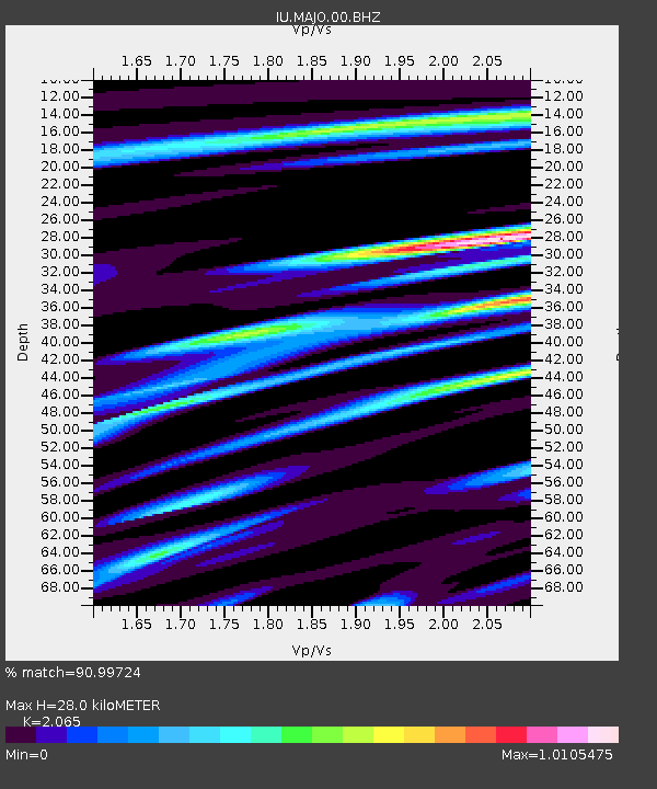
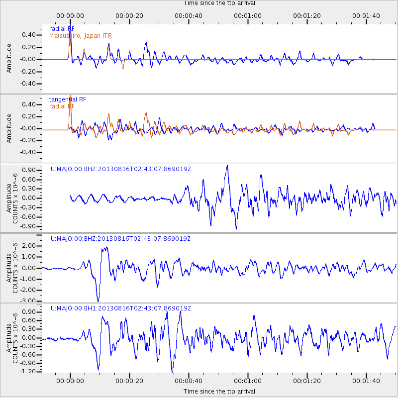
MAJO Matsushiro, Japan - Earthquake Result Viewer

Earthquake location: Cook Strait, New Zealand
Earthquake latitude/longitude: -41.7/174.2
Earthquake time(UTC): 2013/08/16 (228) 02:31:05 GMT
Earthquake Depth: 8.2 km
Earthquake Magnitude: 6.5 MWW, 6.5 MWB, 6.5 MWC, 6.5 MWW, 6.6 MWC, 6.8 MI
Earthquake Catalog/Contributor: NEIC PDE/NEIC COMCAT
Network: IU Global Seismograph Network (GSN - IRIS/USGS)
Station: MAJO Matsushiro, Japan
Lat/Lon: 36.55 N/138.20 E
Elevation: 405 m
Distance: 84.6 deg
Az: 331.648 deg
Baz: 153.809 deg
Ray Param: 0.045396466
Estimated Moho Depth: 28.0 km
Estimated Crust Vp/Vs: 2.07
Assumed Crust Vp: 6.461 km/s
Estimated Crust Vs: 3.129 km/s
Estimated Crust Poisson's Ratio: 0.35
Radial Match: 90.99724 %
Radial Bump: 400
Transverse Match: 79.818085 %
Transverse Bump: 400
SOD ConfigId: 626651
Insert Time: 2014-04-18 00:50:36.127 +0000
GWidth: 2.5
Max Bumps: 400
Tol: 0.001

Signal To Noise

ChannelStoNSTALTA
IU:MAJO:00:BHZ:20130816T02:43:07.869019Z4.42194752.1358986E-74.8302216E-8
IU:MAJO:00:BH1:20130816T02:43:07.869019Z1.76937278.8250694E-84.9876824E-8
IU:MAJO:00:BH2:20130816T02:43:07.869019Z0.62030414.5764267E-87.377715E-8
Arrivals
Ps4.7 SECOND
PpPs13 SECOND
PsPs/PpSs18 SECOND