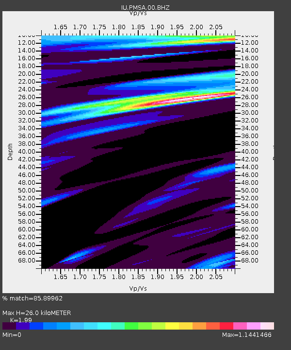
PMSA Palmer Station, Antarctica - Earthquake Result Viewer
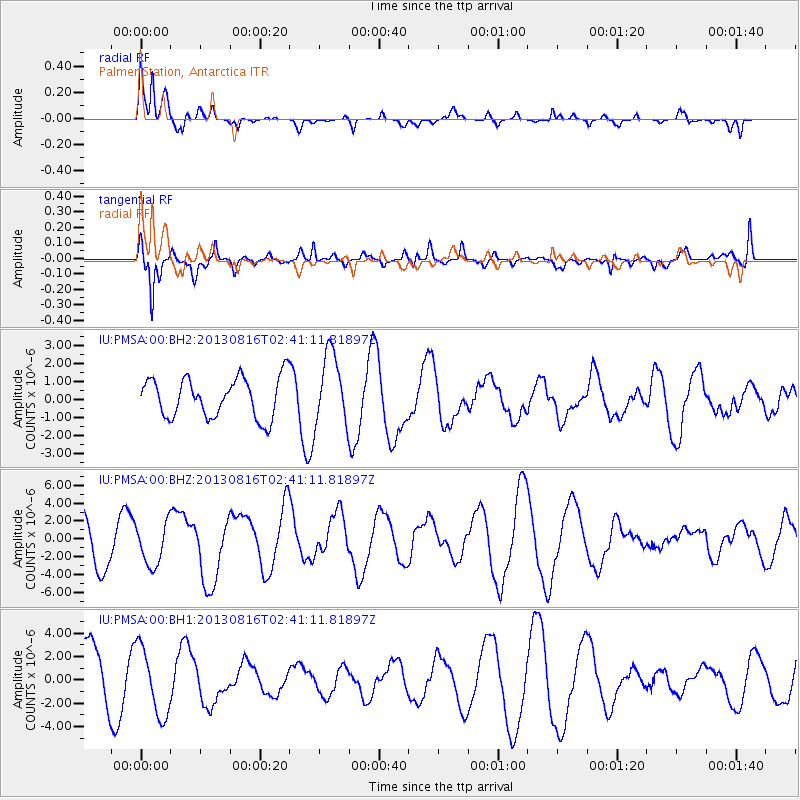
Earthquake location: Cook Strait, New Zealand
Earthquake latitude/longitude: -41.7/174.2
Earthquake time(UTC): 2013/08/16 (228) 02:31:05 GMT
Earthquake Depth: 8.2 km
Earthquake Magnitude: 6.5 MWW, 6.5 MWB, 6.5 MWC, 6.5 MWW, 6.6 MWC, 6.8 MI
Earthquake Catalog/Contributor: NEIC PDE/NEIC COMCAT
Network: IU Global Seismograph Network (GSN - IRIS/USGS)
Station: PMSA Palmer Station, Antarctica
Lat/Lon: 64.77 S/64.05 W
Elevation: 40 m
Distance: 64.5 deg
Az: 156.206 deg
Baz: 224.801 deg
Ray Param: 0.058873054
Estimated Moho Depth: 26.0 km
Estimated Crust Vp/Vs: 1.99
Assumed Crust Vp: 6.183 km/s
Estimated Crust Vs: 3.107 km/s
Estimated Crust Poisson's Ratio: 0.33
Radial Match: 85.89962 %
Radial Bump: 348
Transverse Match: 74.313705 %
Transverse Bump: 394
SOD ConfigId: 626651
Insert Time: 2014-04-18 00:50:47.915 +0000
GWidth: 2.5
Max Bumps: 400
Tol: 0.001

Signal To Noise

ChannelStoNSTALTA
IU:PMSA:00:BHZ:20130816T02:41:11.81897Z0.87416712.3695402E-62.7106262E-6
IU:PMSA:00:BH1:20130816T02:41:11.81897Z1.20581332.9314685E-62.4311132E-6
IU:PMSA:00:BH2:20130816T02:41:11.81897Z1.79728041.989607E-61.1070098E-6
Arrivals
Ps4.3 SECOND
PpPs12 SECOND
PsPs/PpSs16 SECOND