You are here: Home > Network List > IU - Global Seismograph Network (GSN - IRIS/USGS) Stations List
> Station PMG Port Moresby, New Guinea > Earthquake Result Viewer
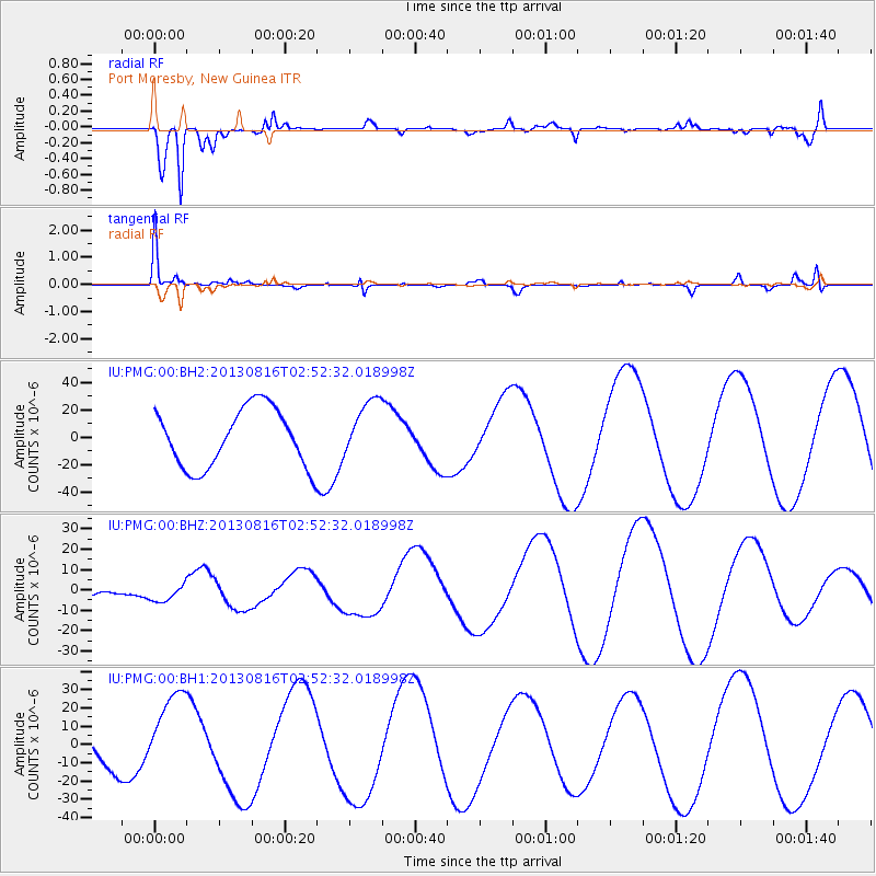
PMG Port Moresby, New Guinea - Earthquake Result Viewer
*The percent match for this event was below the threshold and hence no stack was calculated.
| Earthquake location: |
Cook Strait, New Zealand |
| Earthquake latitude/longitude: |
-41.8/174.1 |
| Earthquake time(UTC): |
2013/08/16 (228) 02:45:27 GMT |
| Earthquake Depth: |
5.8 km |
| Earthquake Magnitude: |
5.6 MW, 5.5 MWR, 5.6 MWC |
| Earthquake Catalog/Contributor: |
NEIC PDE/NEIC COMCAT |
|
| Network: |
IU Global Seismograph Network (GSN - IRIS/USGS) |
| Station: |
PMG Port Moresby, New Guinea |
| Lat/Lon: |
9.40 S/147.16 E |
| Elevation: |
90 m |
|
| Distance: |
40.0 deg |
| Az: |
315.936 deg |
| Baz: |
148.178 deg |
| Ray Param: |
$rayparam |
*The percent match for this event was below the threshold and hence was not used in the summary stack. |
|
| Radial Match: |
69.816666 % |
| Radial Bump: |
400 |
| Transverse Match: |
77.095894 % |
| Transverse Bump: |
223 |
| SOD ConfigId: |
626651 |
| Insert Time: |
2014-04-18 00:58:18.462 +0000 |
| GWidth: |
2.5 |
| Max Bumps: |
400 |
| Tol: |
0.001 |
|
Signal To Noise
| Channel | StoN | STA | LTA |
| IU:PMG:00:BHZ:20130816T02:52:32.018998Z | 0.5245327 | 3.8791427E-6 | 7.395426E-6 |
| IU:PMG:00:BH1:20130816T02:52:32.018998Z | 3.8050063 | 2.3125094E-5 | 6.077544E-6 |
| IU:PMG:00:BH2:20130816T02:52:32.018998Z | 1.0147598 | 2.1720898E-5 | 2.1404965E-5 |
| Arrivals |
| Ps | |
| PpPs | |
| PsPs/PpSs | |


