You are here: Home > Network List > IC - New China Digital Seismograph Network Stations List
> Station KMI Kunming, Yunnan Province, China > Earthquake Result Viewer
KMI Kunming, Yunnan Province, China - Earthquake Result Viewer
| Earthquake location: |
Cook Strait, New Zealand |
| Earthquake latitude/longitude: |
-41.7/174.1 |
| Earthquake time(UTC): |
2013/08/16 (228) 03:09:08 GMT |
| Earthquake Depth: |
8.5 km |
| Earthquake Magnitude: |
5.9 MW, 5.8 MWR, 5.9 MWW, 5.9 MWW, 6.0 MWC |
| Earthquake Catalog/Contributor: |
NEIC PDE/NEIC COMCAT |
|
| Network: |
IC New China Digital Seismograph Network |
| Station: |
KMI Kunming, Yunnan Province, China |
| Lat/Lon: |
25.12 N/102.74 E |
| Elevation: |
1975 m |
|
| Distance: |
93.6 deg |
| Az: |
300.641 deg |
| Baz: |
134.741 deg |
| Ray Param: |
0.041230664 |
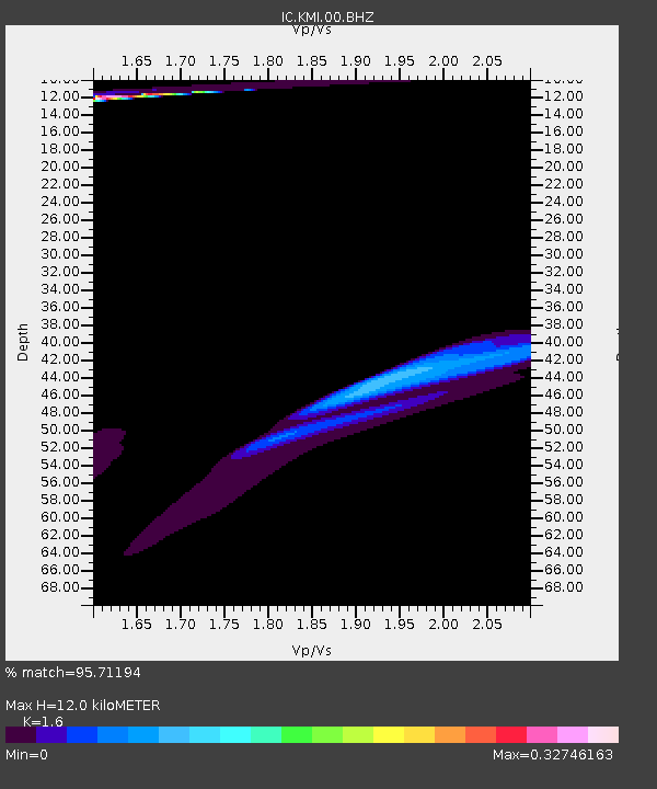
| Estimated Moho Depth: |
12.0 km |
| Estimated Crust Vp/Vs: |
1.60 |
| Assumed Crust Vp: |
6.247 km/s |
| Estimated Crust Vs: |
3.904 km/s |
| Estimated Crust Poisson's Ratio: |
0.18 |
|
| Radial Match: |
95.71194 % |
| Radial Bump: |
330 |
| Transverse Match: |
66.10501 % |
| Transverse Bump: |
400 |
| SOD ConfigId: |
626651 |
| Insert Time: |
2014-04-18 01:06:01.399 +0000 |
| GWidth: |
2.5 |
| Max Bumps: |
400 |
| Tol: |
0.001 |
|
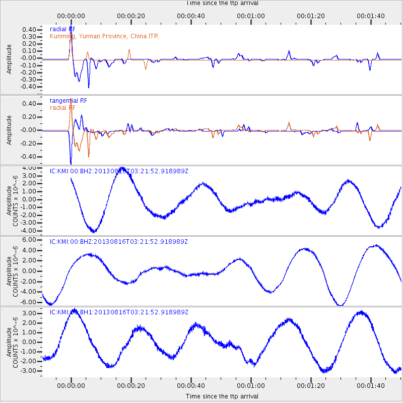
Signal To Noise
| Channel | StoN | STA | LTA |
| IC:KMI:00:BHZ:20130816T03:21:52.918989Z | 0.60880417 | 2.5958282E-6 | 4.263815E-6 |
| IC:KMI:00:BH1:20130816T03:21:52.918989Z | 3.9938421 | 3.225462E-6 | 8.076087E-7 |
| IC:KMI:00:BH2:20130816T03:21:52.918989Z | 0.8154711 | 2.1394028E-6 | 2.6235177E-6 |
| Arrivals |
| Ps | 1.2 SECOND |
| PpPs | 4.9 SECOND |
| PsPs/PpSs | 6.1 SECOND |


