You are here: Home > Network List > G - GEOSCOPE Stations List
> Station TAM Tamanrasset, Algeria > Earthquake Result Viewer
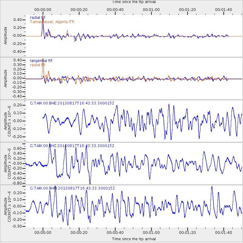
TAM Tamanrasset, Algeria - Earthquake Result Viewer
*The percent match for this event was below the threshold and hence no stack was calculated.
| Earthquake location: |
Southwest Indian Ridge |
| Earthquake latitude/longitude: |
-34.9/54.1 |
| Earthquake time(UTC): |
2013/08/17 (229) 16:32:31 GMT |
| Earthquake Depth: |
10 km |
| Earthquake Magnitude: |
6.1 MWW, 6.1 MWB, 6.2 MWW, 6.2 MWC |
| Earthquake Catalog/Contributor: |
NEIC PDE/NEIC COMCAT |
|
| Network: |
G GEOSCOPE |
| Station: |
TAM Tamanrasset, Algeria |
| Lat/Lon: |
22.79 N/5.53 E |
| Elevation: |
1377 m |
|
| Distance: |
73.6 deg |
| Az: |
313.837 deg |
| Baz: |
140.017 deg |
| Ray Param: |
$rayparam |
*The percent match for this event was below the threshold and hence was not used in the summary stack. |
|
| Radial Match: |
78.91832 % |
| Radial Bump: |
400 |
| Transverse Match: |
62.34862 % |
| Transverse Bump: |
400 |
| SOD ConfigId: |
626651 |
| Insert Time: |
2014-04-18 01:19:57.494 +0000 |
| GWidth: |
2.5 |
| Max Bumps: |
400 |
| Tol: |
0.001 |
|
Signal To Noise
| Channel | StoN | STA | LTA |
| G:TAM:00:BHZ:20130817T16:43:33.300015Z | 6.3849254 | 3.1806402E-7 | 4.9814837E-8 |
| G:TAM:00:BHN:20130817T16:43:33.300015Z | 1.7744079 | 9.5385836E-8 | 5.3756434E-8 |
| G:TAM:00:BHE:20130817T16:43:33.300015Z | 0.9550948 | 6.186261E-8 | 6.477117E-8 |
| Arrivals |
| Ps | |
| PpPs | |
| PsPs/PpSs | |


