You are here: Home > Network List > IU - Global Seismograph Network (GSN - IRIS/USGS) Stations List
> Station KBL Kabul, Afghanistan > Earthquake Result Viewer
KBL Kabul, Afghanistan - Earthquake Result Viewer
| Earthquake location: |
Southwest Indian Ridge |
| Earthquake latitude/longitude: |
-34.9/54.1 |
| Earthquake time(UTC): |
2013/08/17 (229) 16:32:31 GMT |
| Earthquake Depth: |
10 km |
| Earthquake Magnitude: |
6.1 MWW, 6.1 MWB, 6.2 MWW, 6.2 MWC |
| Earthquake Catalog/Contributor: |
NEIC PDE/NEIC COMCAT |
|
| Network: |
IU Global Seismograph Network (GSN - IRIS/USGS) |
| Station: |
KBL Kabul, Afghanistan |
| Lat/Lon: |
34.54 N/69.04 E |
| Elevation: |
1920 m |
|
| Distance: |
70.5 deg |
| Az: |
13.06 deg |
| Baz: |
193.005 deg |
| Ray Param: |
0.054962415 |
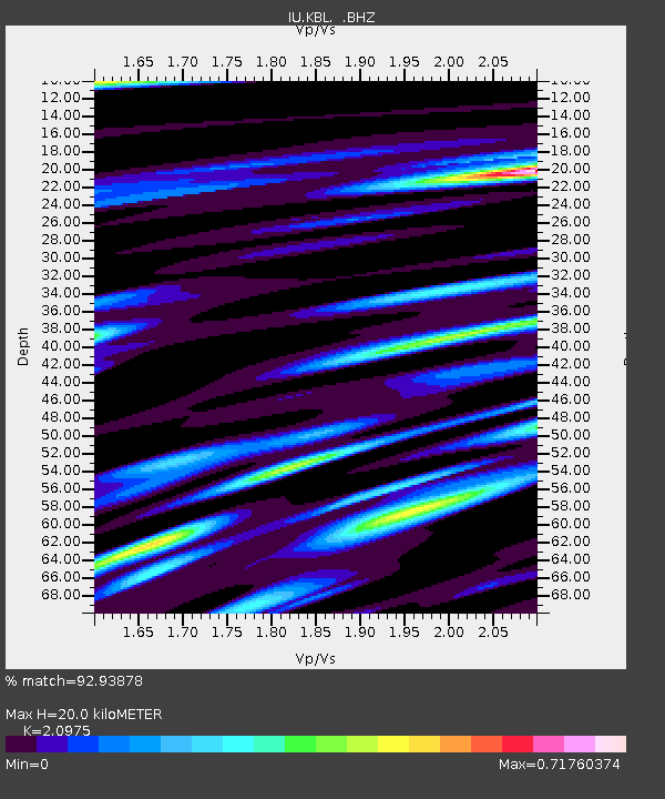
| Estimated Moho Depth: |
20.0 km |
| Estimated Crust Vp/Vs: |
2.10 |
| Assumed Crust Vp: |
6.641 km/s |
| Estimated Crust Vs: |
3.166 km/s |
| Estimated Crust Poisson's Ratio: |
0.35 |
|
| Radial Match: |
92.93878 % |
| Radial Bump: |
400 |
| Transverse Match: |
88.29207 % |
| Transverse Bump: |
400 |
| SOD ConfigId: |
626651 |
| Insert Time: |
2014-04-18 01:22:41.629 +0000 |
| GWidth: |
2.5 |
| Max Bumps: |
400 |
| Tol: |
0.001 |
|
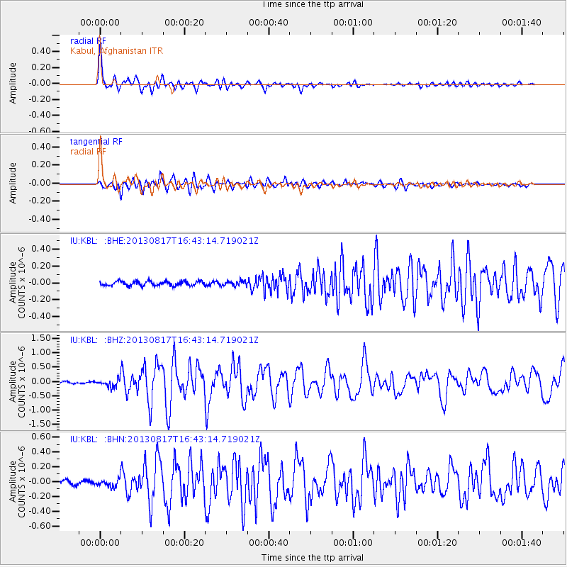
Signal To Noise
| Channel | StoN | STA | LTA |
| IU:KBL: :BHZ:20130817T16:43:14.719021Z | 2.7786362 | 1.2947447E-7 | 4.659641E-8 |
| IU:KBL: :BHN:20130817T16:43:14.719021Z | 1.9190693 | 5.018044E-8 | 2.614832E-8 |
| IU:KBL: :BHE:20130817T16:43:14.719021Z | 1.1221807 | 2.8939048E-8 | 2.5788225E-8 |
| Arrivals |
| Ps | 3.4 SECOND |
| PpPs | 9.0 SECOND |
| PsPs/PpSs | 12 SECOND |


