You are here: Home > Network List > IU - Global Seismograph Network (GSN - IRIS/USGS) Stations List
> Station KMBO Kilima Mbogo, Kenya > Earthquake Result Viewer
KMBO Kilima Mbogo, Kenya - Earthquake Result Viewer
| Earthquake location: |
Southwest Indian Ridge |
| Earthquake latitude/longitude: |
-34.9/54.1 |
| Earthquake time(UTC): |
2013/08/17 (229) 16:32:31 GMT |
| Earthquake Depth: |
10 km |
| Earthquake Magnitude: |
6.1 MWW, 6.1 MWB, 6.2 MWW, 6.2 MWC |
| Earthquake Catalog/Contributor: |
NEIC PDE/NEIC COMCAT |
|
| Network: |
IU Global Seismograph Network (GSN - IRIS/USGS) |
| Station: |
KMBO Kilima Mbogo, Kenya |
| Lat/Lon: |
1.13 S/37.25 E |
| Elevation: |
1950 m |
|
| Distance: |
37.1 deg |
| Az: |
331.287 deg |
| Baz: |
156.732 deg |
| Ray Param: |
0.07633195 |
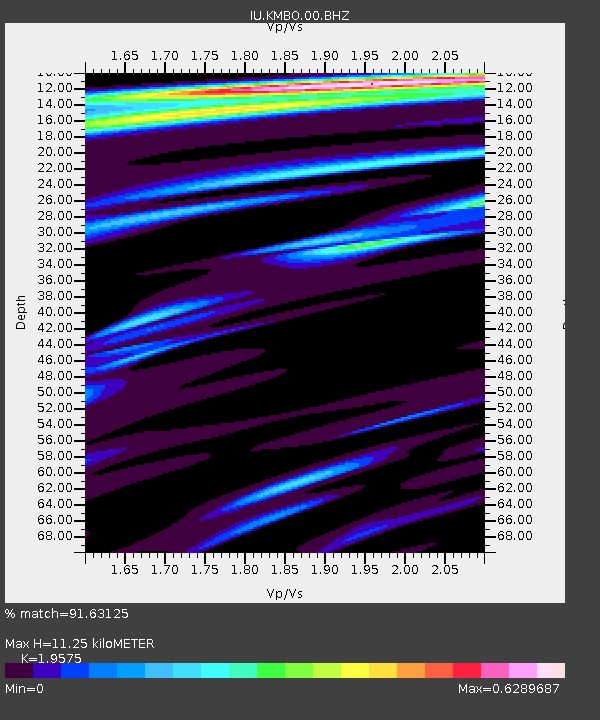
| Estimated Moho Depth: |
11.25 km |
| Estimated Crust Vp/Vs: |
1.96 |
| Assumed Crust Vp: |
6.601 km/s |
| Estimated Crust Vs: |
3.372 km/s |
| Estimated Crust Poisson's Ratio: |
0.32 |
|
| Radial Match: |
91.63125 % |
| Radial Bump: |
293 |
| Transverse Match: |
51.539642 % |
| Transverse Bump: |
400 |
| SOD ConfigId: |
626651 |
| Insert Time: |
2014-04-18 01:22:44.644 +0000 |
| GWidth: |
2.5 |
| Max Bumps: |
400 |
| Tol: |
0.001 |
|

Signal To Noise
| Channel | StoN | STA | LTA |
| IU:KMBO:00:BHZ:20130817T16:39:10.869015Z | 5.321407 | 6.2466296E-7 | 1.1738681E-7 |
| IU:KMBO:00:BH1:20130817T16:39:10.869015Z | 2.8362954 | 4.4192865E-7 | 1.5581193E-7 |
| IU:KMBO:00:BH2:20130817T16:39:10.869015Z | 1.1716032 | 1.0003727E-7 | 8.538493E-8 |
| Arrivals |
| Ps | 1.8 SECOND |
| PpPs | 4.7 SECOND |
| PsPs/PpSs | 6.4 SECOND |


