You are here: Home > Network List > MN - MEDNET Project Stations List
> Station PDG Podgorica, Crna Gora > Earthquake Result Viewer
PDG Podgorica, Crna Gora - Earthquake Result Viewer
| Earthquake location: |
Southwest Indian Ridge |
| Earthquake latitude/longitude: |
-34.9/54.1 |
| Earthquake time(UTC): |
2013/08/17 (229) 16:32:31 GMT |
| Earthquake Depth: |
10 km |
| Earthquake Magnitude: |
6.1 MWW, 6.1 MWB, 6.2 MWW, 6.2 MWC |
| Earthquake Catalog/Contributor: |
NEIC PDE/NEIC COMCAT |
|
| Network: |
MN MEDNET Project |
| Station: |
PDG Podgorica, Crna Gora |
| Lat/Lon: |
42.43 N/19.26 E |
| Elevation: |
40 m |
|
| Distance: |
83.3 deg |
| Az: |
334.799 deg |
| Baz: |
151.784 deg |
| Ray Param: |
0.04629494 |
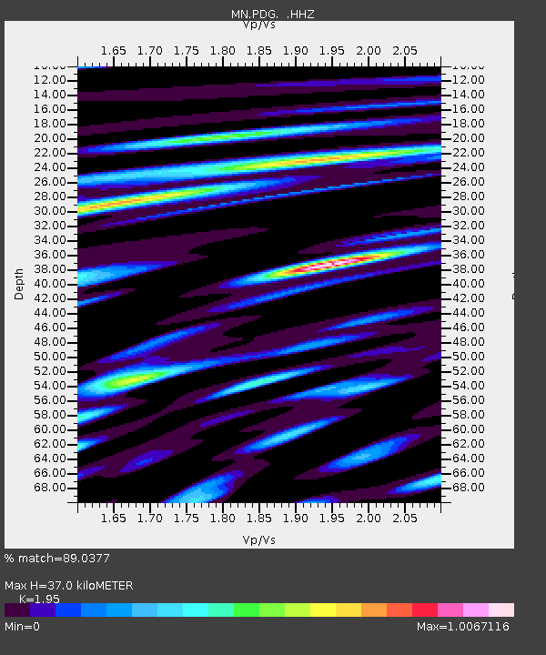
| Estimated Moho Depth: |
37.0 km |
| Estimated Crust Vp/Vs: |
1.95 |
| Assumed Crust Vp: |
6.291 km/s |
| Estimated Crust Vs: |
3.226 km/s |
| Estimated Crust Poisson's Ratio: |
0.32 |
|
| Radial Match: |
89.0377 % |
| Radial Bump: |
400 |
| Transverse Match: |
86.19308 % |
| Transverse Bump: |
400 |
| SOD ConfigId: |
626651 |
| Insert Time: |
2014-04-18 01:24:28.966 +0000 |
| GWidth: |
2.5 |
| Max Bumps: |
400 |
| Tol: |
0.001 |
|

Signal To Noise
| Channel | StoN | STA | LTA |
| MN:PDG: :HHZ:20130817T16:44:26.724026Z | 2.5651865 | 2.0300834E-7 | 7.91398E-8 |
| MN:PDG: :HHN:20130817T16:44:26.724026Z | 1.7413135 | 1.0145329E-7 | 5.8262508E-8 |
| MN:PDG: :HHE:20130817T16:44:26.724026Z | 0.800281 | 4.2089194E-8 | 5.259302E-8 |
| Arrivals |
| Ps | 5.7 SECOND |
| PpPs | 17 SECOND |
| PsPs/PpSs | 23 SECOND |


