You are here: Home > Network List > CI - Caltech Regional Seismic Network Stations List
> Station TIN Tinemaha, California, USA > Earthquake Result Viewer
TIN Tinemaha, California, USA - Earthquake Result Viewer
| Earthquake location: |
Off Coast Of Southern Chile |
| Earthquake latitude/longitude: |
-40.5/-74.8 |
| Earthquake time(UTC): |
1999/08/22 (234) 09:35:39 GMT |
| Earthquake Depth: |
33 km |
| Earthquake Magnitude: |
6.2 MB, 5.8 MS, 6.4 MW, 6.2 MW |
| Earthquake Catalog/Contributor: |
WHDF/NEIC |
|
| Network: |
CI Caltech Regional Seismic Network |
| Station: |
TIN Tinemaha, California, USA |
| Lat/Lon: |
37.05 N/118.23 W |
| Elevation: |
1164 m |
|
| Distance: |
86.9 deg |
| Az: |
326.548 deg |
| Baz: |
148.307 deg |
| Ray Param: |
0.043686155 |
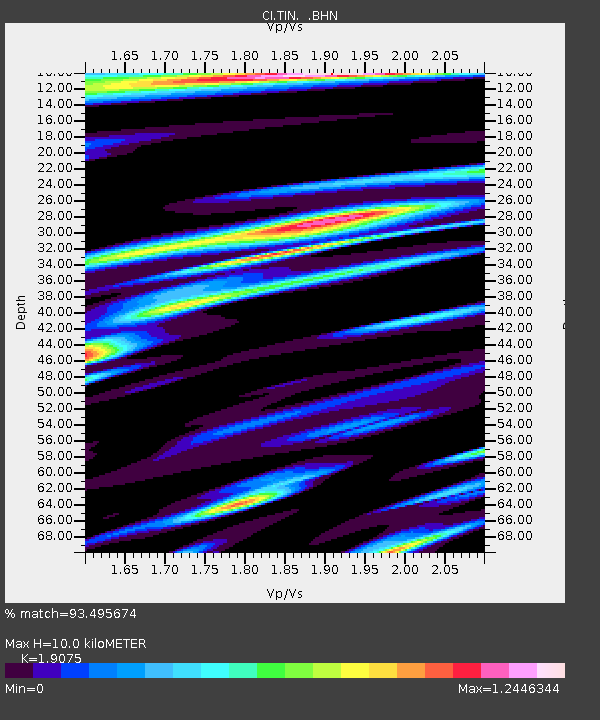
| Estimated Moho Depth: |
10.0 km |
| Estimated Crust Vp/Vs: |
1.91 |
| Assumed Crust Vp: |
6.291 km/s |
| Estimated Crust Vs: |
3.298 km/s |
| Estimated Crust Poisson's Ratio: |
0.31 |
|
| Radial Match: |
93.495674 % |
| Radial Bump: |
362 |
| Transverse Match: |
86.94438 % |
| Transverse Bump: |
400 |
| SOD ConfigId: |
3787 |
| Insert Time: |
2010-02-25 20:49:55.437 +0000 |
| GWidth: |
2.5 |
| Max Bumps: |
400 |
| Tol: |
0.001 |
|
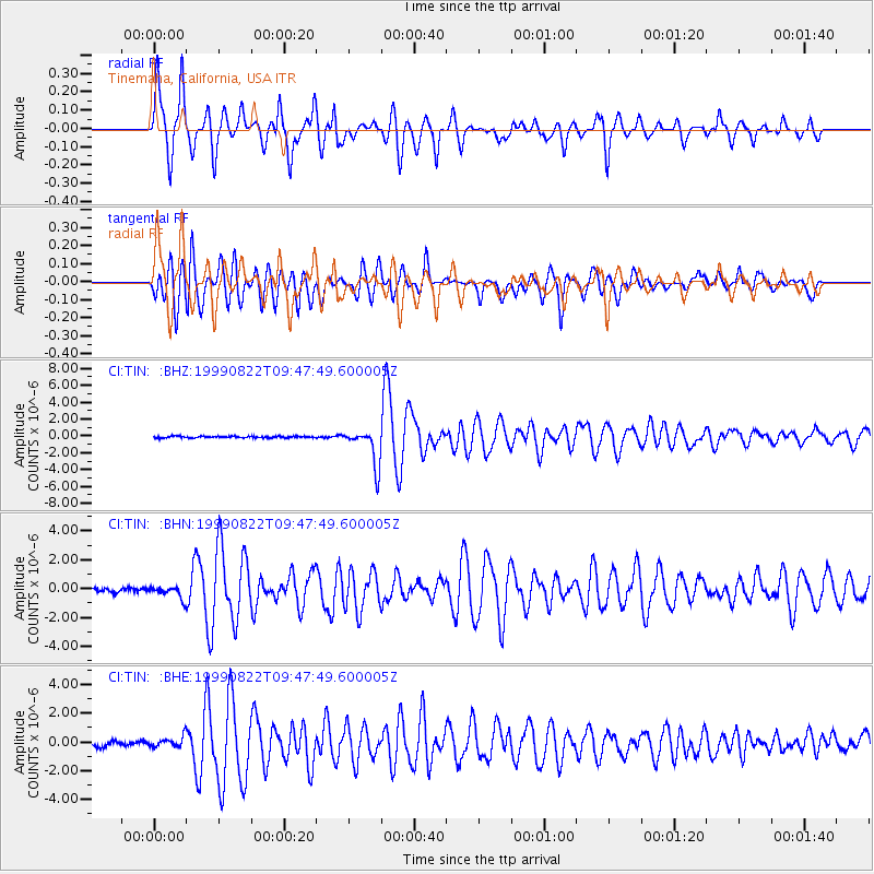
Signal To Noise
| Channel | StoN | STA | LTA |
| CI:TIN: :BHN:19990822T09:47:49.600005Z | 2.9634311 | 4.2949713E-7 | 1.4493239E-7 |
| CI:TIN: :BHE:19990822T09:47:49.600005Z | 1.7615097 | 3.5771382E-7 | 2.030723E-7 |
| CI:TIN: :BHZ:19990822T09:47:49.600005Z | 22.103695 | 2.2142879E-6 | 1.00177274E-7 |
| Arrivals |
| Ps | 1.5 SECOND |
| PpPs | 4.5 SECOND |
| PsPs/PpSs | 6.0 SECOND |


