You are here: Home > Network List > BK - Berkeley Digital Seismograph Network Stations List
> Station CMB Columbia College, Columbia, CA > Earthquake Result Viewer
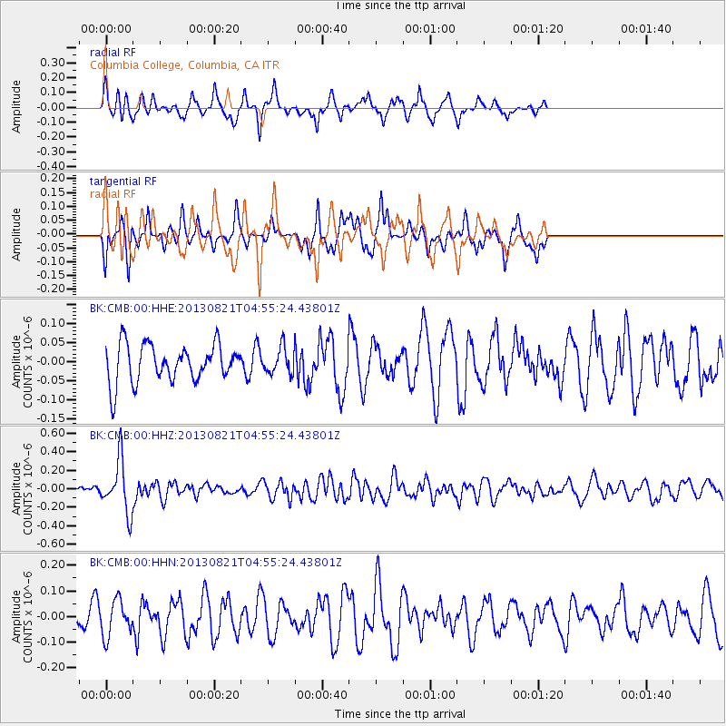
CMB Columbia College, Columbia, CA - Earthquake Result Viewer
*The percent match for this event was below the threshold and hence no stack was calculated.
| Earthquake location: |
Southeast Of Loyalty Islands |
| Earthquake latitude/longitude: |
-22.3/171.7 |
| Earthquake time(UTC): |
2013/08/21 (233) 04:43:18 GMT |
| Earthquake Depth: |
92 km |
| Earthquake Magnitude: |
5.7 MWW, 5.7 MWB, 5.7 MWC |
| Earthquake Catalog/Contributor: |
NEIC PDE/NEIC COMCAT |
|
| Network: |
BK Berkeley Digital Seismograph Network |
| Station: |
CMB Columbia College, Columbia, CA |
| Lat/Lon: |
38.03 N/120.39 W |
| Elevation: |
697 m |
|
| Distance: |
87.5 deg |
| Az: |
47.099 deg |
| Baz: |
239.22 deg |
| Ray Param: |
$rayparam |
*The percent match for this event was below the threshold and hence was not used in the summary stack. |
|
| Radial Match: |
66.45797 % |
| Radial Bump: |
361 |
| Transverse Match: |
48.74518 % |
| Transverse Bump: |
280 |
| SOD ConfigId: |
626651 |
| Insert Time: |
2014-04-18 01:32:32.099 +0000 |
| GWidth: |
2.5 |
| Max Bumps: |
400 |
| Tol: |
0.001 |
|
Signal To Noise
| Channel | StoN | STA | LTA |
| BK:CMB:00:HHZ:20130821T04:55:24.43801Z | 6.9778614 | 2.8707495E-7 | 4.1140822E-8 |
| BK:CMB:00:HHN:20130821T04:55:24.43801Z | 1.0572165 | 7.021308E-8 | 6.641316E-8 |
| BK:CMB:00:HHE:20130821T04:55:24.43801Z | 0.6856822 | 3.3724266E-8 | 4.9183527E-8 |
| Arrivals |
| Ps | |
| PpPs | |
| PsPs/PpSs | |


