You are here: Home > Network List > G - GEOSCOPE Stations List
> Station INU Inuyama, Japan > Earthquake Result Viewer
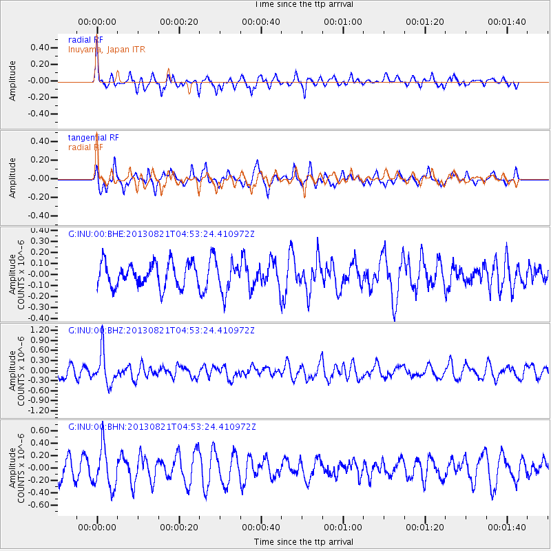
INU Inuyama, Japan - Earthquake Result Viewer
*The percent match for this event was below the threshold and hence no stack was calculated.
| Earthquake location: |
Southeast Of Loyalty Islands |
| Earthquake latitude/longitude: |
-22.3/171.7 |
| Earthquake time(UTC): |
2013/08/21 (233) 04:43:18 GMT |
| Earthquake Depth: |
92 km |
| Earthquake Magnitude: |
5.7 MWW, 5.7 MWB, 5.7 MWC |
| Earthquake Catalog/Contributor: |
NEIC PDE/NEIC COMCAT |
|
| Network: |
G GEOSCOPE |
| Station: |
INU Inuyama, Japan |
| Lat/Lon: |
35.35 N/137.03 E |
| Elevation: |
132 m |
|
| Distance: |
66.1 deg |
| Az: |
329.446 deg |
| Baz: |
144.836 deg |
| Ray Param: |
$rayparam |
*The percent match for this event was below the threshold and hence was not used in the summary stack. |
|
| Radial Match: |
63.72216 % |
| Radial Bump: |
398 |
| Transverse Match: |
72.40758 % |
| Transverse Bump: |
386 |
| SOD ConfigId: |
626651 |
| Insert Time: |
2014-04-18 01:35:42.118 +0000 |
| GWidth: |
2.5 |
| Max Bumps: |
400 |
| Tol: |
0.001 |
|
Signal To Noise
| Channel | StoN | STA | LTA |
| G:INU:00:BHZ:20130821T04:53:24.410972Z | 3.4003396 | 4.981358E-7 | 1.464959E-7 |
| G:INU:00:BHN:20130821T04:53:24.410972Z | 2.238775 | 3.3285383E-7 | 1.4867678E-7 |
| G:INU:00:BHE:20130821T04:53:24.410972Z | 1.27212 | 1.3542223E-7 | 1.06453975E-7 |
| Arrivals |
| Ps | |
| PpPs | |
| PsPs/PpSs | |


