You are here: Home > Network List > TA - USArray Transportable Network (new EarthScope stations) Stations List
> Station H04D Lebanon, OR, USA > Earthquake Result Viewer
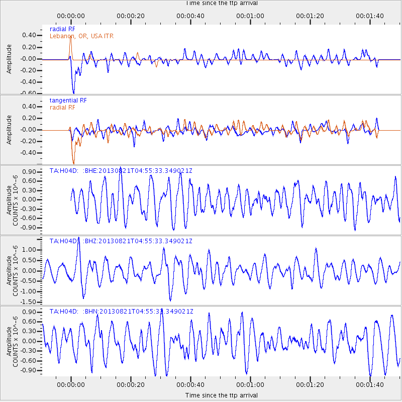
H04D Lebanon, OR, USA - Earthquake Result Viewer
*The percent match for this event was below the threshold and hence no stack was calculated.
| Earthquake location: |
Southeast Of Loyalty Islands |
| Earthquake latitude/longitude: |
-22.3/171.7 |
| Earthquake time(UTC): |
2013/08/21 (233) 04:43:18 GMT |
| Earthquake Depth: |
92 km |
| Earthquake Magnitude: |
5.7 MWW, 5.7 MWB, 5.7 MWC |
| Earthquake Catalog/Contributor: |
NEIC PDE/NEIC COMCAT |
|
| Network: |
TA USArray Transportable Network (new EarthScope stations) |
| Station: |
H04D Lebanon, OR, USA |
| Lat/Lon: |
44.52 N/122.74 W |
| Elevation: |
284 m |
|
| Distance: |
89.4 deg |
| Az: |
40.649 deg |
| Baz: |
237.5 deg |
| Ray Param: |
$rayparam |
*The percent match for this event was below the threshold and hence was not used in the summary stack. |
|
| Radial Match: |
56.275566 % |
| Radial Bump: |
400 |
| Transverse Match: |
42.589188 % |
| Transverse Bump: |
393 |
| SOD ConfigId: |
626651 |
| Insert Time: |
2014-04-18 01:41:36.209 +0000 |
| GWidth: |
2.5 |
| Max Bumps: |
400 |
| Tol: |
0.001 |
|
Signal To Noise
| Channel | StoN | STA | LTA |
| TA:H04D: :BHZ:20130821T04:55:33.349021Z | 2.2851844 | 8.0130553E-7 | 3.5065247E-7 |
| TA:H04D: :BHN:20130821T04:55:33.349021Z | 0.8954628 | 4.0294938E-7 | 4.499901E-7 |
| TA:H04D: :BHE:20130821T04:55:33.349021Z | 1.1334548 | 5.0749117E-7 | 4.4773833E-7 |
| Arrivals |
| Ps | |
| PpPs | |
| PsPs/PpSs | |


