You are here: Home > Network List > UU - University of Utah Regional Network Stations List
> Station KNB Kanab, UT, USA > Earthquake Result Viewer
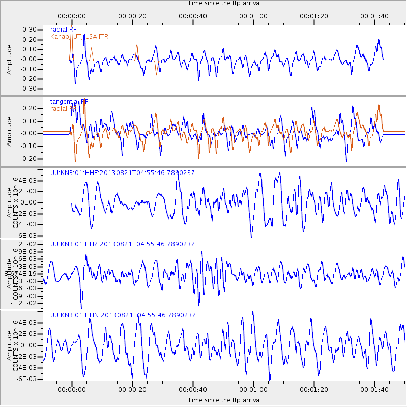
KNB Kanab, UT, USA - Earthquake Result Viewer
*The percent match for this event was below the threshold and hence no stack was calculated.
| Earthquake location: |
Southeast Of Loyalty Islands |
| Earthquake latitude/longitude: |
-22.3/171.7 |
| Earthquake time(UTC): |
2013/08/21 (233) 04:43:18 GMT |
| Earthquake Depth: |
92 km |
| Earthquake Magnitude: |
5.7 MWW, 5.7 MWB, 5.7 MWC |
| Earthquake Catalog/Contributor: |
NEIC PDE/NEIC COMCAT |
|
| Network: |
UU University of Utah Regional Network |
| Station: |
KNB Kanab, UT, USA |
| Lat/Lon: |
37.02 N/112.82 W |
| Elevation: |
1715 m |
|
| Distance: |
92.3 deg |
| Az: |
50.857 deg |
| Baz: |
243.817 deg |
| Ray Param: |
$rayparam |
*The percent match for this event was below the threshold and hence was not used in the summary stack. |
|
| Radial Match: |
63.878128 % |
| Radial Bump: |
400 |
| Transverse Match: |
55.03207 % |
| Transverse Bump: |
400 |
| SOD ConfigId: |
626651 |
| Insert Time: |
2014-04-18 01:43:06.291 +0000 |
| GWidth: |
2.5 |
| Max Bumps: |
400 |
| Tol: |
0.001 |
|
Signal To Noise
| Channel | StoN | STA | LTA |
| UU:KNB:01:HHZ:20130821T04:55:46.789023Z | 2.4406154 | 5.202926E-9 | 2.1318092E-9 |
| UU:KNB:01:HHN:20130821T04:55:46.789023Z | 1.1434574 | 2.5436582E-9 | 2.2245326E-9 |
| UU:KNB:01:HHE:20130821T04:55:46.789023Z | 1.2897607 | 2.1265474E-9 | 1.6487921E-9 |
| Arrivals |
| Ps | |
| PpPs | |
| PsPs/PpSs | |


