WDC Whiskeytown, CA - Earthquake Result Viewer
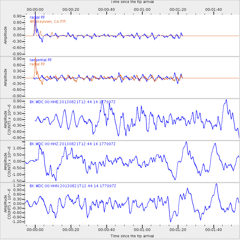
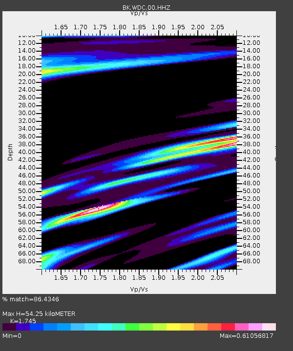
Earthquake location: Near Coast Of Guerrero, Mexico
Earthquake latitude/longitude: 16.9/-99.5
Earthquake time(UTC): 2013/08/21 (233) 12:38:29 GMT
Earthquake Depth: 21 km
Earthquake Magnitude: 6.2 MWW, 6.2 MWW, 6.2 MWB, 6.2 MWC
Earthquake Catalog/Contributor: NEIC PDE/NEIC COMCAT
Network: BK Berkeley Digital Seismograph Network
Station: WDC Whiskeytown, CA
Lat/Lon: 40.58 N/122.54 W
Elevation: 268 m
Distance: 30.9 deg
Az: 324.514 deg
Baz: 133.135 deg
Ray Param: 0.079196535
Estimated Moho Depth: 54.25 km
Estimated Crust Vp/Vs: 1.75
Assumed Crust Vp: 6.566 km/s
Estimated Crust Vs: 3.763 km/s
Estimated Crust Poisson's Ratio: 0.26
Radial Match: 86.4346 %
Radial Bump: 395
Transverse Match: 65.3601 %
Transverse Bump: 400
SOD ConfigId: 626651
Insert Time: 2014-04-18 01:50:40.379 +0000
GWidth: 2.5
Max Bumps: 400
Tol: 0.001

Signal To Noise

ChannelStoNSTALTA
BK:WDC:00:HHZ:20130821T12:44:14.177997Z6.16681676.2961885E-71.0209788E-7
BK:WDC:00:HHN:20130821T12:44:14.177997Z2.11156273.062159E-71.450186E-7
BK:WDC:00:HHE:20130821T12:44:14.177997Z1.55320143.4436542E-72.217133E-7
Arrivals
Ps6.7 SECOND
PpPs21 SECOND
PsPs/PpSs28 SECOND