You are here: Home > Network List > CC - Cascade Chain Volcano Monitoring Stations List
> Station SWNB Southwest, Newberry, OR > Earthquake Result Viewer
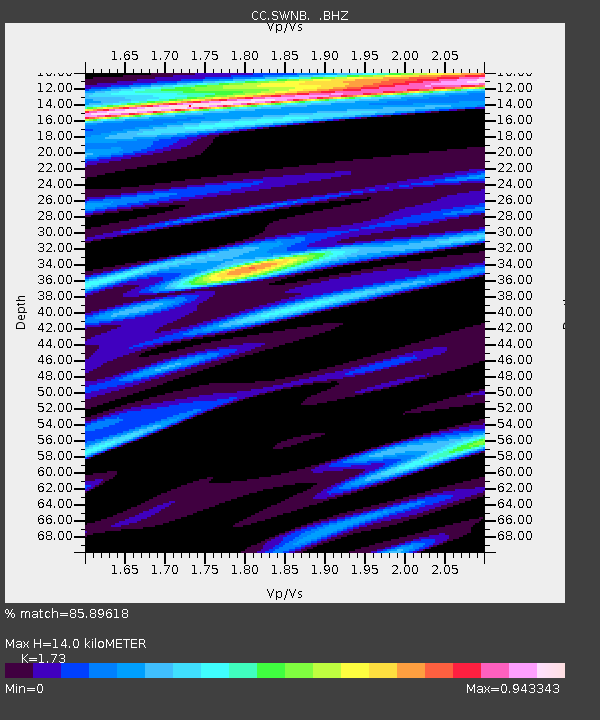
SWNB Southwest, Newberry, OR - Earthquake Result Viewer
| Earthquake location: |
Near Coast Of Guerrero, Mexico |
| Earthquake latitude/longitude: |
16.9/-99.5 |
| Earthquake time(UTC): |
2013/08/21 (233) 12:38:29 GMT |
| Earthquake Depth: |
21 km |
| Earthquake Magnitude: |
6.2 MWW, 6.2 MWW, 6.2 MWB, 6.2 MWC |
| Earthquake Catalog/Contributor: |
NEIC PDE/NEIC COMCAT |
|
| Network: |
CC Cascade Chain Volcano Monitoring |
| Station: |
SWNB Southwest, Newberry, OR |
| Lat/Lon: |
43.67 N/121.36 W |
| Elevation: |
1569 m |
|
| Distance: |
32.5 deg |
| Az: |
329.819 deg |
| Baz: |
138.443 deg |
| Ray Param: |
0.078601964 |
| Estimated Moho Depth: |
14.0 km |
| Estimated Crust Vp/Vs: |
1.73 |
| Assumed Crust Vp: |
6.597 km/s |
| Estimated Crust Vs: |
3.814 km/s |
| Estimated Crust Poisson's Ratio: |
0.25 |
|
| Radial Match: |
85.89618 % |
| Radial Bump: |
375 |
| Transverse Match: |
73.683716 % |
| Transverse Bump: |
400 |
| SOD ConfigId: |
626651 |
| Insert Time: |
2014-04-18 01:51:17.497 +0000 |
| GWidth: |
2.5 |
| Max Bumps: |
400 |
| Tol: |
0.001 |
|

Signal To Noise
| Channel | StoN | STA | LTA |
| CC:SWNB: :BHZ:20130821T12:44:28.219989Z | 9.918657 | 1.3304012E-6 | 1.3413118E-7 |
| CC:SWNB: :BHN:20130821T12:44:28.219989Z | 2.5451593 | 4.416861E-7 | 1.7353966E-7 |
| CC:SWNB: :BHE:20130821T12:44:28.219989Z | 4.403813 | 6.9863944E-7 | 1.5864421E-7 |
| Arrivals |
| Ps | 1.7 SECOND |
| PpPs | 5.3 SECOND |
| PsPs/PpSs | 7.0 SECOND |


